Android Apps
>
Maps & Navigation
> Paid
Category
Maps & Navigation
Sort by
Trending
Recent downloads
All-time downloads
Top rated
Popular in
Filter by
Off
Free
Paid
New
Updated
Price Reduced
No ads
Page 8 of the popular Paid Maps & Navigation Apps for Android in Australia
Kärnten Lakes - Austria Charts
MAPITECH LTD

MapiTech launches on the market the best official up-to-date combined with S57 nautical charts (digital): marinas, wrecks, fishing spots, boat ramps, POI.
Lakes in this App : Aichwaldsee,AfritzerSe…


$4.99
0.0
5+ downloads
|
Maps & Navigation
0.0
$4.99
MAPITECH LTD
5+ downloads
TRANSPORTATION
5+ downloads
TRANSPORTATION
Kärnten Lakes - Austria Charts
MapiTech launches on the market the best official up-to-date combined with S57 nautical charts (digital): marinas, wre…
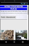
Satnav Cycle Routes – Perth(2)
Ian Lochhead

Perth - Glenalmond. 35 miles
Perth - Crieff. 38 miles
Perth - Milnathort. 38 miles
Satnav Cycle Routes around Perth using cycle paths and roads. Every route has turn-by-turn navigation with voice in…

$0.99
0.0
0+ downloads
|
Maps & Navigation
0.0
$0.99
Ian Lochhead
0+ downloads
TRANSPORTATION
0+ downloads
TRANSPORTATION
Satnav Cycle Routes – Perth(2)
Perth - Glenalmond. 35 miles
Perth - Crieff. 38 miles
Perth - Milnathort. 38 miles
Satnav Cycle Routes around Perth us…
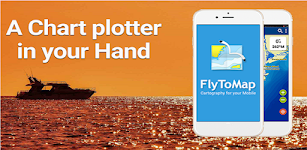
Wilson Lake Alabama GPS Charts
FLYTOMAP INC

Flytomap is a valid and interesting alternative,
Featured on the Deck
Featured on Geomedia
Worldwide Marine and Outdoor Maps available when connected, thanks to viewer.flytomap.com
Worldwide Satellit…


$2.99
0.0
0+ downloads
|
Maps & Navigation
0.0
$2.99
FLYTOMAP INC
0+ downloads
TRANSPORTATION
0+ downloads
TRANSPORTATION
Wilson Lake Alabama GPS Charts
Flytomap is a valid and interesting alternative,
Featured on the Deck
Featured on Geomedia
Worldwide Marine and Outdoor…
The Blue Hills Reservation Map
FLYTOMAP INC

Flytomap is a valid and interesting alternative,
Featured on the Deck
Featured on Geomedia
Try now the new FlyToMap web viewer to see all available maps worldwide !!! Visit viewer.flytomap.com
&ldqu…


$3.99
0.0
1+ downloads
|
Maps & Navigation
0.0
$3.99
FLYTOMAP INC
1+ downloads
TRANSPORTATION
1+ downloads
TRANSPORTATION
The Blue Hills Reservation Map
Flytomap is a valid and interesting alternative,
Featured on the Deck
Featured on Geomedia
Try now the new FlyToMap web…
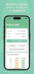
Transportes Andalucía PRO
Fran Caballero Software

AVAILABLE ON ENGLISH.
Enhance your journeys across Andalusia (Andalucía, Spain) with our public transportation app. Instantly access updated schedules for buses, trains, metro, and boats acro…

$3.49
0.0
10+ downloads
|
Maps & Navigation
0.0
$3.49
Fran Caballero Software
10+ downloads
TRANSPORTATION
10+ downloads
TRANSPORTATION
Transportes Andalucía PRO
AVAILABLE ON ENGLISH.
Enhance your journeys across Andalusia (Andalucía, Spain) with our public transportation …
Old Hickory Lake GPS Charts
FLYTOMAP INC

Flytomap is a valid and interesting alternative,
Featured on the Deck
Featured on Geomedia
Worldwide Marine and Outdoor Maps available when connected, thanks to viewer.flytomap.com
Worldwide Satelli…

$3.99
0.0
1+ downloads
|
Maps & Navigation
0.0
$3.99
FLYTOMAP INC
1+ downloads
TRANSPORTATION
1+ downloads
TRANSPORTATION
Old Hickory Lake GPS Charts
Flytomap is a valid and interesting alternative,
Featured on the Deck
Featured on Geomedia
Worldwide Marine and Outdoo…
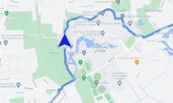
Satnav Cycle Routes – York
Ian Lochhead

3 Satnav Cycle Routes around York.
1. Around York - 19.5 miles
2. York to Stamford Bridge - 28.3 miles
3. York to Tadcaster - 21.3 miles
Satnav Cycle Routes around York using cycle paths and roads. …


$0.99
0.0
1+ downloads
|
Maps & Navigation
0.0
$0.99
Ian Lochhead
1+ downloads
TRANSPORTATION
1+ downloads
TRANSPORTATION
Satnav Cycle Routes – York
3 Satnav Cycle Routes around York.
1. Around York - 19.5 miles
2. York to Stamford Bridge - 28.3 miles
3. York to Tadca…
GPS Compass Navigation Pro
Darko Belev

From now on your hiking, hill climbing and walking will be easy. Use compass, navigation, record your routes, save your locations, take photos with GPS tag... and much more.
COMPASS
- Magnetic and t…


$4.99
0.0
50+ downloads
|
Maps & Navigation
0.0
$4.99
Darko Belev
50+ downloads
TRANSPORTATION
50+ downloads
TRANSPORTATION
GPS Compass Navigation Pro
From now on your hiking, hill climbing and walking will be easy. Use compass, navigation, record your routes, save your…
Gps For Boat fishing & Car - P
V.Mark.

Be careful after the application is installed and the map appears, close and reopen the application to work properly.
Maps: Satellite,Simple,Terrain,OpenStreetMap,Seamap,OpenTopo
This GPS is speci…


$12.99
0.0
10+ downloads
|
Maps & Navigation
0.0
$12.99
V.Mark.
10+ downloads
TRANSPORTATION
10+ downloads
TRANSPORTATION
Gps For Boat fishing & Car - P
Be careful after the application is installed and the map appears, close and reopen the application to work properly.
…
Isola del Giglio GPS Navigator
FLYTOMAP INC

Flytomap is a valid and interesting alternative,
Featured on the Deck
Featured on Geomedia
Worldwide Marine and Outdoor Maps available when connected, thanks to viewer.flytomap.com
Worldwide Satelli…


$3.99
0.0
0+ downloads
|
Maps & Navigation
0.0
$3.99
FLYTOMAP INC
0+ downloads
TRANSPORTATION
0+ downloads
TRANSPORTATION
Isola del Giglio GPS Navigator
Flytomap is a valid and interesting alternative,
Featured on the Deck
Featured on Geomedia
Worldwide Marine and Outdoo…
Huron Erie Ontario Lakes Chart
FLYTOMAP INC

Flytomap is a valid and interesting alternative,
Featured on the Deck
Featured on Geomedia
Worldwide Marine and Outdoor Maps available when connected, thanks to viewer.flytomap.com
Worldwide Satelli…


$3.99
0.0
10+ downloads
|
Maps & Navigation
0.0
$3.99
FLYTOMAP INC
10+ downloads
TRANSPORTATION
10+ downloads
TRANSPORTATION
Huron Erie Ontario Lakes Chart
Flytomap is a valid and interesting alternative,
Featured on the Deck
Featured on Geomedia
Worldwide Marine and Outdoo…
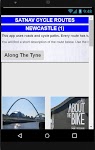
Satnav Cycle Routes-Newcastle1
Ian Lochhead

1. Along the Tyne - 15 miles
2. Newcastle to Gateshead - 23.5 miles
3. Newcastle to Sunderland - 39 miles
Satnav Cycle Routes around Newcastle using cycle paths and roads. Every route has turn-by-tu…


$0.99
0.0
0+ downloads
|
Maps & Navigation
0.0
$0.99
Ian Lochhead
0+ downloads
TRANSPORTATION
0+ downloads
TRANSPORTATION
Satnav Cycle Routes-Newcastle1
1. Along the Tyne - 15 miles
2. Newcastle to Gateshead - 23.5 miles
3. Newcastle to Sunderland - 39 miles
Satnav Cycle…
Thorsborne Trail
Jonathan Ide

This is the only app for hikers either walking or thinking of walking the iconic Thorsborne Trail on World Heritage listed Hinchinbrook Island in Far North Queensland, Australia. It is the perfect el…


$4.49
0.0
1,000+ downloads
|
Maps & Navigation
0.0
$4.49
Jonathan Ide
1,000+ downloads
TRANSPORTATION
1,000+ downloads
TRANSPORTATION
Thorsborne Trail
This is the only app for hikers either walking or thinking of walking the iconic Thorsborne Trail on World Heritage lis…
Como Park Lake Zoo Map & Guide
GeoPOI LLC

Como Park is one of the most visited destinations in Minnesota, and for good reason! Located in northwest Saint Paul in Ramsey County, Como Park was established in 1884 and has a rich history as an p…


$0.49
0.0
1+ downloads
|
Maps & Navigation
0.0
$0.49
GeoPOI LLC
1+ downloads
TRANSPORTATION
1+ downloads
TRANSPORTATION
Como Park Lake Zoo Map & Guide
Como Park is one of the most visited destinations in Minnesota, and for good reason! Located in northwest Saint Paul in…
Satnav CycleRoutes–Dunfermline
Ian Lochhead

Dunfermline - Kincardine. 28.6 miles
Dunfermline - Limekilns. 14.4 miles
Satnav Cycle Routes around Dunfermline using cycle paths and roads. Every route has turn-by-turn navigation with voice instru…


$0.99
0.0
0+ downloads
|
Maps & Navigation
0.0
$0.99
Ian Lochhead
0+ downloads
TRANSPORTATION
0+ downloads
TRANSPORTATION
Satnav CycleRoutes–Dunfermline
Dunfermline - Kincardine. 28.6 miles
Dunfermline - Limekilns. 14.4 miles
Satnav Cycle Routes around Dunfermline using …
Cantabria GPS Map Navigator
FLYTOMAP INC

Flytomap is a valid and interesting alternative,
Featured on the Deck
Featured on Geomedia
Worldwide Marine and Outdoor Maps available when connected, thanks to viewer.flytomap.com
Worldwide Satellit…


$3.99
0.0
10+ downloads
|
Maps & Navigation
0.0
$3.99
FLYTOMAP INC
10+ downloads
TRANSPORTATION
10+ downloads
TRANSPORTATION
Cantabria GPS Map Navigator
Flytomap is a valid and interesting alternative,
Featured on the Deck
Featured on Geomedia
Worldwide Marine and Outdoor…
Luiz Correa-french Guiana maps
FLYTOMAP INC

Flytomap is a valid and interesting alternative,
Featured on the Deck
Featured on Geomedia
Worldwide Marine and Outdoor Maps available when connected, thanks to viewer.flytomap.com
Worldwide Satelli…


$3.99
0.0
0+ downloads
|
Maps & Navigation
0.0
$3.99
FLYTOMAP INC
0+ downloads
TRANSPORTATION
0+ downloads
TRANSPORTATION
Luiz Correa-french Guiana maps
Flytomap is a valid and interesting alternative,
Featured on the Deck
Featured on Geomedia
Worldwide Marine and Outdoo…
Lake Ontario GPS Map Navigator
FLYTOMAP INC

Flytomap is a valid and interesting alternative,
Worldwide Marine and Outdoor Maps available when connected, thanks to viewer.flytomap.com
Worldwide Satellite images overlay on charts
Worldwide Ter…


$3.99
0.0
10+ downloads
|
Maps & Navigation
0.0
$3.99
FLYTOMAP INC
10+ downloads
TRANSPORTATION
10+ downloads
TRANSPORTATION
Lake Ontario GPS Map Navigator
Flytomap is a valid and interesting alternative,
Worldwide Marine and Outdoor Maps available when connected, thanks to…
Haida Gwaii Mushroom Forager
GeoPOI LLC

The forests and woodlands of the Pacific Northwest and British Columbia, Canada are ecosystems rich with edible wild mushrooms if you know where to look. Trouble is, seasoned wild edible collectors s…

$0.49
0.0
0+ downloads
|
Maps & Navigation
0.0
$0.49
GeoPOI LLC
0+ downloads
TRANSPORTATION
0+ downloads
TRANSPORTATION
Haida Gwaii Mushroom Forager
The forests and woodlands of the Pacific Northwest and British Columbia, Canada are ecosystems rich with edible wild mu…
Vancouver Is. Mushroom Forager
GeoPOI LLC

The forests and woodlands of the Pacific Northwest and British Columbia, Canada are ecosystems rich with edible wild mushrooms if you know where to look. Trouble is, seasoned wild edible collectors s…


$1.49
0.0
10+ downloads
|
Maps & Navigation
0.0
$1.49
GeoPOI LLC
10+ downloads
TRANSPORTATION
10+ downloads
TRANSPORTATION
Vancouver Is. Mushroom Forager
The forests and woodlands of the Pacific Northwest and British Columbia, Canada are ecosystems rich with edible wild mu…
More apps
Android Statistics
© 2010-2024 - AppBrain