AppBrain
|
Apps
Apps
Apps being viewed right now
Trending apps today
Most popular apps
All-time most downloaded apps
Top rated apps
Statistics
Docs
Developers
Sign up
Log in
Android Apps
>
Maps & Navigation
>
Paid
Category
Maps & Navigation
Sort by
Trending
Recent downloads
All-time downloads
Top rated
Popular in
Filter by
Off
Free
Paid
New
Updated
Price Reduced
No ads
Page 8 of the
popular Paid Maps & Navigation Apps for Android in Hong Kong
Cancun GPS Map Navigator – Click to show
Cancun GPS Map Navigator
FLYTOMAP INC
Flytomap is a valid and interesting alternative, Featured on the Deck Featured on Geomedia Worldwide Marine and Outdoor Maps available when connected, thanks to viewer.flytomap.com Worldwide Satellit…
$3.99
0.0
5+ downloads
|
Maps & Navigation
0.0
$3.99
FLYTOMAP INC
5+ downloads
TRANSPORTATION
Cancun GPS Map Navigator
Flytomap is a valid and interesting alternative, Featured on the Deck Featured on Geomedia Worldwide Marine and Outdoor…
Vancouver Is. Mushroom Forager – Click to show
Vancouver Is. Mushroom Forager
GeoPOI LLC
The forests and woodlands of the Pacific Northwest and British Columbia, Canada are ecosystems rich with edible wild mushrooms if you know where to look. Trouble is, seasoned wild edible collectors s…
$1.49
0.0
10+ downloads
|
Maps & Navigation
0.0
$1.49
GeoPOI LLC
10+ downloads
TRANSPORTATION
Vancouver Is. Mushroom Forager
The forests and woodlands of the Pacific Northwest and British Columbia, Canada are ecosystems rich with edible wild mu…
Float LOZ
Jason Sanford
Lake of the Ozarks' boating app. Learn your way around Lake of the Ozarks. Navigate to marinas, boat launches, restaurants, mile markers, and more. Save your favorite spots and share them with friend…
$2.99
0.0
10+ downloads
|
Maps & Navigation
0.0
$2.99
Jason Sanford
10+ downloads
TRANSPORTATION
Float LOZ
Lake of the Ozarks' boating app. Learn your way around Lake of the Ozarks. Navigate to marinas, boat launches, restaura…
Harry S Truman RSVR GPS Charts – Click to show
Harry S Truman RSVR GPS Charts
MAPITECH LTD
MapiTech launches on the market the best official up-to-date NOAA RNC (raster) combined with S57 nautical charts (digital): marinas, wrecks, fishing spots, boat ramps, POI. This app displays seamles…
$4.99
0.0
0+ downloads
|
Maps & Navigation
0.0
$4.99
MAPITECH LTD
0+ downloads
TRANSPORTATION
Harry S Truman RSVR GPS Charts
MapiTech launches on the market the best official up-to-date NOAA RNC (raster) combined with S57 nautical charts (digit…
Tims Ford Lake TN Offline Maps – Click to show
Tims Ford Lake TN Offline Maps
MAPITECH LTD
MapiTech launches on the market the best official up-to-date RNC (raster) combined with S57 nautical charts (digital): marinas, wrecks, fishing spots, boat ramps, POI. This app displays seamlessly …
$4.99
0.0
1+ downloads
|
Maps & Navigation
0.0
$4.99
MAPITECH LTD
1+ downloads
TRANSPORTATION
Tims Ford Lake TN Offline Maps
MapiTech launches on the market the best official up-to-date RNC (raster) combined with S57 nautical charts (digital):…
ExploreMetro VIP
Matthew Mayer
Purchase this app to become an ExploreMetro VIP, and enjoy our other metro map apps for seven cities in Asia with no ads. Supports: Explore Shanghai, Beijing, Guangzhou, Hong Kong, Singapore, Taipei…
$3.49
5.0
1,000+ downloads
|
Maps & Navigation
5.0
$3.49
Matthew Mayer
1,000+ downloads
TRANSPORTATION
ExploreMetro VIP
Purchase this app to become an ExploreMetro VIP, and enjoy our other metro map apps for seven cities in Asia with no ad…
AllPaths Pro: All the Paths
Tambucho
AllPaths, the application for Android devices specially designed for lovers of nature, Hiking, Mountain, Cycling, MTB, etc. DETAILED MANUAL: http://www.tambucho.es/android/allpaths/allpaths_en.pdf …
$6.99
0.0
1+ downloads
|
Maps & Navigation
0.0
$6.99
Tambucho
1+ downloads
TRANSPORTATION
AllPaths Pro: All the Paths
AllPaths, the application for Android devices specially designed for lovers of nature, Hiking, Mountain, Cycling, MTB, …
Almicantarat
Pierre-Louis Deschamps
Enjoy shooting stars, planets and the Sun with an easy-to-use, professional and accurate celestial navigation app. Features a smooth 3D Sky Map. Check the celestial fix on the device native map. Use …
$4.99
0.0
50+ downloads
|
Maps & Navigation
0.0
$4.99
Pierre-Louis Deschamps
50+ downloads
TRANSPORTATION
Almicantarat
Enjoy shooting stars, planets and the Sun with an easy-to-use, professional and accurate celestial navigation app. Feat…
TMBmap Tour du Mont Blanc TMB
ARiS websitewerk
This App shows the Tour du Mont Blanc route with all its variations. On the free website TMBmap.com you can organize your self-guided TMB route: Create your personal TMB route, plan accommodations …
$13.99
0.0
10+ downloads
|
Maps & Navigation
0.0
$13.99
ARiS websitewerk
10+ downloads
TRANSPORTATION
TMBmap Tour du Mont Blanc TMB
This App shows the Tour du Mont Blanc route with all its variations. On the free website TMBmap.com you can organize yo…
Champlain lake Offline Charts – Click to show
Champlain lake Offline Charts
MAPITECH LTD
MapiTech launches on the market the best official up-to-date NOAA RNC (raster) combined with S57 nautical charts (digital): marinas, wrecks, fishing spots, boat ramps, POI. This app displays seamles…
$4.99
0.0
50+ downloads
|
Maps & Navigation
0.0
$4.99
MAPITECH LTD
50+ downloads
TRANSPORTATION
Champlain lake Offline Charts
MapiTech launches on the market the best official up-to-date NOAA RNC (raster) combined with S57 nautical charts (digit…
Lake District Outdoor Map Pro – Click to show
Lake District Outdoor Map Pro
jonathan shutt
An offline map of the Lake District National Park in England, ideal for hiking, running, mountain biking / cycling. Being offline means unlike other map apps, you don't need a signal to access detail…
$1.99
0.0
1,000+ downloads
|
Maps & Navigation
0.0
$1.99
jonathan shutt
1,000+ downloads
TRANSPORTATION
Lake District Outdoor Map Pro
An offline map of the Lake District National Park in England, ideal for hiking, running, mountain biking / cycling. Bei…
Performance
amenai technologies
Performance - Calculateur de Performance Aéronautique Optimisez vos décisions de vol avec Performance, le calculateur professionnel qui transforme les données constructeur en per…
$3.49
0.0
10+ downloads
|
Maps & Navigation
0.0
$3.49
amenai technologies
10+ downloads
TRANSPORTATION
Performance
Performance - Calculateur de Performance Aéronautique Optimisez vos décisions de vol avec Performance, le…
Lake Tahoe Offline GPS Charts – Click to show
Lake Tahoe Offline GPS Charts
MAPITECH LTD
MapiTech launches on the market the best official up-to-date NOAA RNC (raster) combined with S57 nautical charts (digital): marinas, wrecks, fishing spots, boat ramps, POI. This app displays seamles…
$4.99
0.0
1+ downloads
|
Maps & Navigation
0.0
$4.99
MAPITECH LTD
1+ downloads
TRANSPORTATION
Lake Tahoe Offline GPS Charts
MapiTech launches on the market the best official up-to-date NOAA RNC (raster) combined with S57 nautical charts (digit…
Norris Lake TN Offline Charts – Click to show
Norris Lake TN Offline Charts
MAPITECH LTD
MapiTech launches on the market the best official up-to-date NOAA RNC (raster) combined with S57 nautical charts (digital): marinas, wrecks, fishing spots, boat ramps, POI. This app displays seamles…
$4.99
0.0
10+ downloads
|
Maps & Navigation
0.0
$4.99
MAPITECH LTD
10+ downloads
TRANSPORTATION
Norris Lake TN Offline Charts
MapiTech launches on the market the best official up-to-date NOAA RNC (raster) combined with S57 nautical charts (digit…
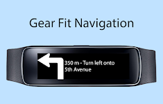
Gear Fit Navigation – Click to show
Gear Fit Navigation
SmartWatch Studios
This application displays Google Navigation instructions on your Samsung Gear Fit 1 smartwatch. (Not compatible with Gear Fit2!) Note: - Supports horizontal and vertical layout - Additional to the …
$1.99
2.4
10,000+ downloads
|
Maps & Navigation
2.4
$1.99
SmartWatch Studios
10,000+ downloads
TRANSPORTATION
Gear Fit Navigation
This application displays Google Navigation instructions on your Samsung Gear Fit 1 smartwatch. (Not compatible with Ge…
Catalonia GPS Map Navigator – Click to show
Catalonia GPS Map Navigator
FLYTOMAP INC
Flytomap is a valid and interesting alternative, Featured on the Deck Featured on Geomedia Worldwide Marine and Outdoor Maps available when connected, thanks to viewer.flytomap.com Worldwide Satellit…
$3.99
0.0
10+ downloads
|
Maps & Navigation
0.0
$3.99
FLYTOMAP INC
10+ downloads
TRANSPORTATION
Catalonia GPS Map Navigator
Flytomap is a valid and interesting alternative, Featured on the Deck Featured on Geomedia Worldwide Marine and Outdoor…
Potomac River Was GPS Charts – Click to show
Potomac River Was GPS Charts
FLYTOMAP INC
Flytomap is a valid and interesting alternative, Worldwide Marine and Outdoor Maps available when connected, thanks to viewer.flytomap.com Worldwide Satellite images overlay on charts Worldwide Ter…
$2.99
0.0
10+ downloads
|
Maps & Navigation
0.0
$2.99
FLYTOMAP INC
10+ downloads
TRANSPORTATION
Potomac River Was GPS Charts
Flytomap is a valid and interesting alternative, Worldwide Marine and Outdoor Maps available when connected, thanks to…
PRO Voice Navigator "IGH"
rausNT
This app is a voice-based navigator. "I'm going home" is primarily intended for trekking enthusiasts, since it's a navigator for cross-country conditions. If you are afraid of getting lost…
$2.99
5.0
10,000+ downloads
|
Maps & Navigation
5.0
$2.99
rausNT
10,000+ downloads
TRANSPORTATION
PRO Voice Navigator "IGH"
This app is a voice-based navigator. "I'm going home" is primarily intended for trekking enthusiasts, since …
Treinenradar
René van den Berg
Volg treinen op het Nederlands spoor. Inclusief: - NS intercity's en sprinters - Arriva - Thalys (HSL-Zuid) - TRAXX (HSL-Zuid) Recent changes: - Verbeterde interface - Nieuw logo - Extra filters - …
$3.99
0.0
100+ downloads
|
Maps & Navigation
0.0
$3.99
René van den Berg
100+ downloads
TRANSPORTATION
Treinenradar
Volg treinen op het Nederlands spoor. Inclusief: - NS intercity's en sprinters - Arriva - Thalys (HSL-Zuid) - TRAXX (H…
Lake Wakatipu NZ Offline Chart – Click to show
Lake Wakatipu NZ Offline Chart
MAPITECH LTD
MapiTech launches on the market the best official up-to-date NOAA RNC (raster) combined with S57 nautical charts (digital): marinas, wrecks, fishing spots, boat ramps, POI. This app displays seamles…
$4.99
0.0
0+ downloads
|
Maps & Navigation
0.0
$4.99
MAPITECH LTD
0+ downloads
TRANSPORTATION
Lake Wakatipu NZ Offline Chart
MapiTech launches on the market the best official up-to-date NOAA RNC (raster) combined with S57 nautical charts (digit…
United States
United Kingdom
Germany
Norway
Sweden
Australia
Netherlands
Italy
Denmark
Hong Kong
Brazil
France
Canada
Spain
Portugal
South Korea
Japan
Poland
Hungary
India
Finland
Thailand
Russia
General
Overall
Applications
Games
Join AppBrain
Join AppBrain to get app recommendations
Apps
Art & Design
Auto & Vehicles
Beauty
Books & Reference
Business
Comics
Communication
Dating
Education
Entertainment
Events
Finance
Food & Drink
Health & Fitness
House & Home
Libraries & Demo
Lifestyle
Maps & Navigation
Medical
Music & Audio
News & Magazines
Parenting
Personalization
Photography
Productivity
Shopping
Social
Sports
Tools
Travel & Local
Video Players & Editors
Weather
Games
Action
Adventure
Arcade
Board
Card
Casino
Casual
Educational
Music
Puzzle
Racing
Role Playing
Simulation
Sports Games
Strategy
Trivia
Word