

AltiMe Pro·Offline Altimeter
AltiMe Pro·Offline Altimeter is made and published by 海峰 程. AppBrain is an independent app data site and isn't affiliated with 海峰 程. The app name, icon, screenshots and description belong to 海峰 程 and are shown as published on the App Store.
AppBrain's verdict
- Rating on App Store
- 5.00
- 3 ratings
- Last updated
- July 22, 2026
It doesn't have enough ratings yet to judge what users think.
Rankings
App Store top chartsApp Store Rankings for AltiMe Pro·Offline Altimeter
Competitors
Similar apps and more from 海峰 程Alternatives to AltiMe Pro·Offline Altimeter


More from 海峰 程


Releases
Updates seen on the App Store- Version
- 1.1.3
- Launched
- February 2026
No changelog data
User feedback
Ratings and reviews on the App StoreComments on AltiMe Pro·Offline Altimeter for iOS
We don't have enough comments to show example comments. Please check back later.
Technology
Found in the app by AppBrain- Price
- Free
- App size
- 38.2 MB
- Content rating
- High
Technologies used by AltiMe Pro·Offline Altimeter
About the app and developer
About AltiMe Pro·Offline Altimeter
AltiMe Pro·Offline Altimeter is a travel app developed by 海峰 程.
User Ratings
AltiMe Pro·Offline Altimeter is rated 5.00 out of 5 stars. The rating is based on 3 ratings.
App Information
AltiMe Pro·Offline Altimeter is freely available from the App Store. The app size is 38.21 MB. The latest version available is 1.1.3. The last update was on July 22, 2026.
Technical Requirements
The app has a content rating of High Maturity. The app has been available on the App Store since February 2026.
Developer information for 海峰 程
Address:
Store listing
By 海峰 程, from the App Store



Description by 海峰 程 Written by the developer, not by AppBrain. Click to read.
Lift your phone and discover the name of every mountain in view.
KEY FEATURES
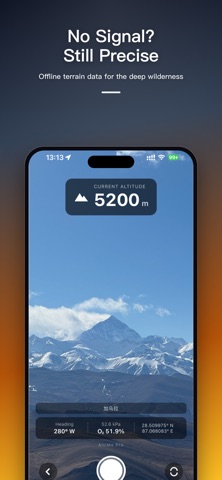
• AR Peak Finder — labels peak names, altitude and distance in real time, backed by a database of tens of thousands of summits
• Real-Time Altitude — dual GPS + barometer engine, accurate to the meter, works even without a signal
• Trajectory Tracking — continuous background tracking of route, distance, total ascent & descent
• Altitude Charts — beautiful graphs to review the full data of every trip
• Works Offline — pre-download terrain data and identify peaks deep in the wild
• More Tools — precise compass, sunrise/sunset, relative oxygen level, photos with altitude watermark
Whether you're mountaineering, hiking, trail-running, cycling or traveling, AltiMe is the pro altimeter in your pocket.
Download AltiMe and set out knowing exactly where you stand.