

ApexGPS Hiking is made and published by Rene Duttra. AppBrain is an independent app data site and isn't affiliated with Rene Duttra. The app name, icon, screenshots and description belong to Rene Duttra and are shown as published on the App Store.
AppBrain's verdict
- Rating on App Store
- 5.00
- 1 ratings
- Last updated
- October 22, 2026
It doesn't have enough ratings yet to judge what users think.
Rankings
App Store top chartsApp Store Rankings for ApexGPS Hiking
Competitors
Similar apps and more from Rene DuttraAlternatives to ApexGPS Hiking


More from Rene Duttra

Releases
Updates seen on the App Store- Version
- 1.10
- Launched
- June 2026
No changelog data
User feedback
Ratings and reviews on the App StoreComments on ApexGPS Hiking for iOS
We don't have enough comments to show example comments. Please check back later.
Technology
Found in the app by AppBrain- Price
- Free
- App size
- 14.8 MB
- Content rating
- Everyone
Technologies used by ApexGPS Hiking
About the app and developer
About ApexGPS Hiking
ApexGPS Hiking is a navigation app developed by Rene Duttra.
User Ratings
ApexGPS Hiking is rated 5.00 out of 5 stars. The rating is based on one rating ratings.
App Information
ApexGPS Hiking is freely available from the App Store. The app size is 14.79 MB. The latest version available is 1.10. The last update was on October 22, 2026.
Technical Requirements
The app has a content rating of Everyone. The app has been available on the App Store since June 2026.
Developer information for Rene Duttra
Address:
Store listing
By Rene Duttra, from the App Store



Description by Rene Duttra Written by the developer, not by AppBrain. Click to read.
LANGUAGES
• English, Deutsch, Français, Español, Polski, and العربية (Arabic) — with full right-to-left layout for Arabic
• Built-in user guide translated into all six languages
MAPS
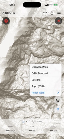
• ESRI Topo (default on new installs)
• OpenTopoMap — topographic tiles with contour lines
• OpenStreetMap Standard
• ESRI World Imagery (satellite)
• ESRI Hillshade (shaded relief)
• Thunderforest Outdoors — contour lines + hiking difficulty shading (free API key required, added in Settings)
• Switch styles with the Layers button; your choice is remembered
OFFLINE
• Tiles cache automatically as you browse, ready for airplane mode
• Download a full region: pan the map to frame the area, pick a zoom range, hit Download
• Cache size adjustable in Settings: 250 MB / 500 MB / 1 GB / 2 GB
• Saved regions are stored separately and survive cache cleanups
TRACK RECORDING
• Keeps recording with the screen locked or while you use other apps
• Live stats card right on the map: running duration, distance, elevation with its source (barometer or GPS), and total ascent — with confirmations so you never end a hike by accident
• True mean-sea-level elevation (with a bundled global geoid correction)
• GPS Diagnostics (Settings → Advanced): see exactly which quality gates each GPS fix passes and why a noisy altitude reading was filtered out — with a plain-language explainer for every gate
GPX IMPORT & EXPORT
• Open .gpx files from the Files app or share them in from WhatsApp, Mail, or any file-sharing app
• Multi-file select for bulk import
TRACK PLANNING
• Sketch a route by tapping the map — drop numbered vertices
• Long-press a vertex to drag, long-press a midpoint to insert a new one
• Fetch the route's elevation profile from a worldwide DEM with one tap
WAYPOINTS
• Add by long-pressing the map, entering coordinates, or via GPX import
• 32 OSM-aligned symbols, 16 colour choices
• Long-press and drag on the map to relocate
• Auto-fetch elevation from a worldwide DEM
• Duplicates from re-imported GPX are automatically deduplicated
WEATHER
• Per-waypoint hourly forecast for the next 7 days (Open-Meteo, no API key)
• Current conditions, pressure + humidity charts, sunrise / sunset / UV index
• Fully localized: temperature units, condition labels, time-of-day follow your phone's language
NAVIGATION & SHARING
• Tap any waypoint to start navigation: dotted line, live distance + bearing, auto-stop on arrival
• Full-screen compass mode for hands-free navigation
• Send your live location as a one-tap link — opens in ApexGPS for recipients who have it, web map preview for everyone else
DISTANCE MEASUREMENT
• Tap to drop vertices; drag any vertex to refine; drag a midpoint handle to insert a new vertex
• Total distance shown live in the stats bar
MAP CONTROLS
• Two-finger twist to rotate the map freely
• Follow-me mode with screen-always-on during GPS tracking, plus a live stats bar: speed, elevation, distance
SAMPLE HIKE
• Load a real recording of the Watzmann Traverse (22.6 km, +2250 m) from Settings → Data and explore the app before your own first hike
BACKUP & RESTORE
• Export tracks, waypoints, saved map regions, and settings to a ZIP file
• Restore on another phone with Merge (deduplicates) or Replace modes
PRIVACY
• All data stays on your device; location is never uploaded anywhere
• Map tiles are fetched from public providers (OpenStreetMap, ESRI, Thunderforest) over anonymous HTTPS requests
• No analytics, no tracking, no ad SDKs
REQUIREMENTS
• iPhone with iOS 17 or later
• Location permission (optional — only needed for follow-me / recording)
• No account, no sign-up
Made in the UAE. Feedback welcome at sandwalker.one@proton.me.