

FlyQ+ EFB
FlyQ+ EFB is made and published by Seattle Avionics, Inc. AppBrain is an independent app data site and isn't affiliated with Seattle Avionics, Inc. The app name, icon, screenshots and description belong to Seattle Avionics, Inc. and are shown as published on the App Store.
AppBrain's verdict
EstablishedWell rated- Rating on App Store
- 4.12
- 907 ratings
- Last updated
- January 24, 2025
- Size
- 494.2 MB
Users rate it well: 4.1 stars from 907 ratings.
User feedback
Ratings and reviews on the App StoreComments on FlyQ+ EFB for iOS
We don't have enough comments to show example comments. Please check back later.
Store listing
By Seattle Avionics, Inc., from the App Store




Description by Seattle Avionics, Inc. Written by the developer, not by AppBrain. Click to read.
New features such as a glide ring, graphical weather briefing, ability to download two data cycles, and a navlog that expands/collapses airways/SIDs/STARs make flying safer and easier than ever before!
The Global Digital Map shows airports, airways, airspace, navaids, and waypoints from all around the world. Text rotates so it's always right-side up and the level of detail adapts to the zoom level.
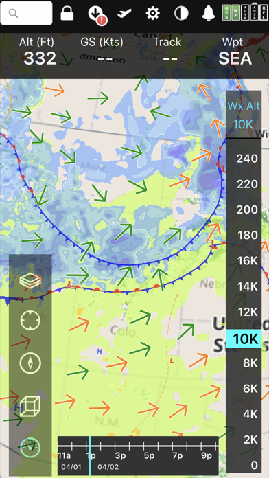
Our exceptional "4D Predictive Weather" system uses a Timeline and Altitude Slider to help you analyze weather at different times - both past and future - and at different altitudes. 17 weather layers from both the Internet and ADS-B (e.g. Radar, Icing, Turbulence, PIREPs, Winds Aloft, Surface Winds, Surface Analysis, Satellite, and more), many tied to the Timeline and Altitude Slider, give you unprecedented pre-flight and in-flight safety.
Supports more than 20 ADS-B and in-panel devices: Stratus 3, Avidyne, Dynon, Stratux, and more.
The exclusive Augmented Reality (AR) feature provides situational awareness you'd previously only seen in sci-fi movies.
The Slingshot wireless system means FlyQ+ supplies maps, plates, and apt diagrams wirelessly to certified systems from BendixKing.
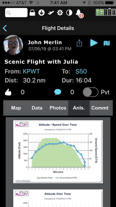
The Visual Logbook and Post Flight Playback / Analysis Graphs add a whole new dimension to your flying. Optionally connect with your friends to "see" and even replay their flights. CFI's can track student progress and remotely send endorsements.
Other key features include split screen, 3D synthetic vision, plates on the map, more than 4,600 airport diagrams, rich Documents support, extended runways, distance measurement, fuel prices, NOTAMS, wind-optimized flight planning, and plates for Mexico and Central America.
NEW! NaviGuard GPS anomaly detection guards against GPS spoofing and jamming
> Maps Your Way
+ Digital, 2D maps, 3D Syn Vis, Augmented Reality
+ Sectionals and IFR charts
+ TACs
+ Photo, road, terrain maps
+ 17 Weather Layers
+ Flight Track
+ Fuel Prices
+ TFRs
+ Obstacle and Terrain Avoidance
+ ADS-B Traffic and Weather
+ Extended runways with right-pattern indicators
+ Procedures on map
+ Rings / Extended Course Line
+ CAP grid
+ Heli and Gulf of Mexico charts
+ VFR Flyways
+ Syn Vis includes HITS boxes, EFIS display, TAWS, Obstacles, and AHRS support.
Night Mode preserves your night vision.
Split screen (iPad only) and single screen.
> Procedures
NEW! FlyQ+ includes the same FAA DO-200B certified Seattle Avionics geo-referenced approach plates and apt diagrams that we supply to certified avionics from Honeywell and Aspen.
Split screen can show a map and a procedure simultaneously.
> Flight Planning that Saves Time and Money
1. Automatically uses recently cleared ATC routes
2. Automatically plans fuel stops based on lowest cost
3. Uses expected winds to plot the fastest course
4. CAP/SAR patterns
5. Exchange flight plans with Dynon SkyView, Avidyne, and Aspen
6. Practice with X-Plane or MS Flight Sim / Prepar3D
> Weather
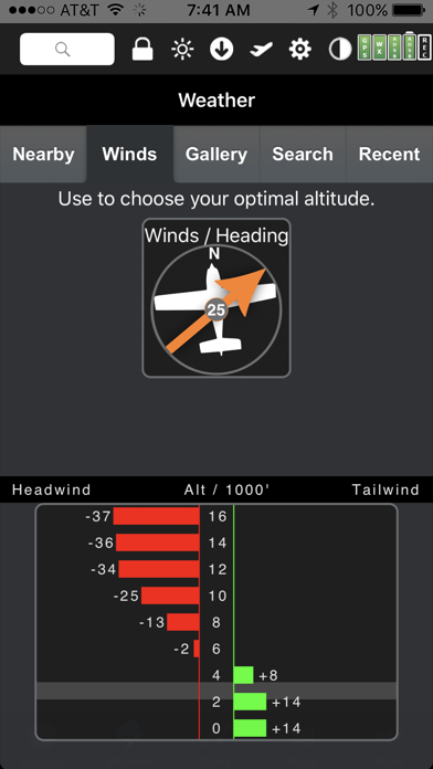
Amazing "4D Predictive Weather" uses a Timeline and Altitude slider to make detailed pre-flight and in-flight analysis easy. The Graphical Wind Optimizer uses red and green bars to show the headwind or tailwind at different altitudes. Also includes an extensive gallery of weather images.
> Airport Information
The Airport screen concisely shows key operational info, sat images, and rwy diagrams on a single screen. Weather, approach procedures, A/FD, and FBO info are just a tap away. Includes more than 4,600 SA Airport Diagrams.
> Data Manager
FlyQ+ makes it painless to download new data every month: spin and zoom a 3D globe to visually select the states you need.
> Try it before you buy it
Experience everything FlyQ+ EFB offers with a free 30-day subscription.
Safety and technology
Found in the app by AppBrain- Price
- Free
- App size
- 494.2 MB
- Content rating
- Everyone
Technologies used by FlyQ+ EFB
Releases
Updates seen on the App Store- Version
- 7.1.1
- Launched
- October 2014
No changelog data
Alternatives
Similar apps and more from Seattle Avionics, Inc.Alternatives to FlyQ+ EFB





Rankings
App Store top chartsApp Store Rankings for FlyQ+ EFB
About the app and developer
About FlyQ+ EFB
FlyQ+ EFB is a navigation app developed by Seattle Avionics, Inc.
User Ratings
FlyQ+ EFB is rated 4.12 out of 5 stars. The rating is based on 910 ratings.
App Information
FlyQ+ EFB is freely available from the App Store. The app size is 494.19 MB. The latest version available is 7.1.1. The last update was on January 24, 2025.
Technical Requirements
The app has a content rating of Everyone. The app has been available on the App Store since October 2014.
Developer information for Seattle Avionics, Inc.
Address:
Frequently asked questions about FlyQ+ EFB
Is FlyQ+ EFB free?
Yes. FlyQ+ EFB is free on the App Store.
Is FlyQ+ EFB still available?
Yes. FlyQ+ EFB is on the App Store, and the last update we saw was on January 24, 2025.
How large is FlyQ+ EFB?
FlyQ+ EFB is 494.19 MB.
Is FlyQ+ EFB suitable for children?
App Store rates the content of FlyQ+ EFB as suitable for everyone.
How do people rate FlyQ+ EFB?
FlyQ+ EFB scores 4.12 out of 5 stars, from 907 ratings on the App Store.
Who made FlyQ+ EFB?
FlyQ+ EFB was developed by Seattle Avionics, Inc. It is listed in the navigation category on the App Store.
What are the best alternatives to FlyQ+ EFB?
People looking at FlyQ+ EFB also look at these navigation apps: iFly EFB, Airmate, FltPlan Go for iPhone, FltPlan Go, WingX®.