

GAB Aviation Tools
GAB Aviation Tools is made and published by GERT ANDREAS BARRING. AppBrain is an independent app data site and isn't affiliated with GERT ANDREAS BARRING. The app name, icon, screenshots and description belong to GERT ANDREAS BARRING and are shown as published on the App Store.
AppBrain's verdict
- Best rank
- #53
- Top Paid, Netherlands
- Rating on App Store
- 5.00
- 1 ratings
- Last updated
- September 19, 2026
It doesn't have enough ratings yet to judge what users think. Its best ranking is #53 in Top Paid, Utilities in Netherlands.
Rankings
App Store top charts- Highest rank
- #53
- Chart
- Top Paid
- Utilities
- Country
- Netherlands
App Store Rankings for GAB Aviation Tools
Top rankings
| Rank | Country | Category | List |
|---|---|---|---|
| 53 | Netherlands | Utilities | Top Paid |
Ranking history in Netherlands
Releases
Updates seen on the App Store- Version
- 1.16
- Launched
- November 2025
No changelog data
User feedback
Ratings and reviews on the App StoreComments on GAB Aviation Tools for iOS
We don't have enough comments to show example comments. Please check back later.
Technology
Found in the app by AppBrain- Price
- $2.99
- App size
- 24.6 MB
- Content rating
- Everyone
Technologies used by GAB Aviation Tools
About the app and developer
About GAB Aviation Tools
GAB Aviation Tools is an utilities app developed by GERT ANDREAS BARRING.
User Ratings
GAB Aviation Tools is rated 5.00 out of 5 stars. The rating is based on one rating ratings.
App Information
GAB Aviation Tools costs $2.99. The app size is 24.61 MB. The latest version available is 1.16. The last update was on September 19, 2026.
Technical Requirements
The app has a content rating of Everyone. The app has been available on the App Store since November 2025.
Developer information for GERT ANDREAS BARRING
Address:
Store listing
By GERT ANDREAS BARRING, from the App Store





Description by GERT ANDREAS BARRING Written by the developer, not by AppBrain. Click to read.
Whether you're preparing for a flight, studying procedures, viewing nearby aircraft, tracking your flying history, or exploring aviation concepts, GAB Aviation Tools provides practical and educational tools in an easy-to-use format.
Key Features:
Live ADS-B & OGN Traffic
Explore nearby air traffic on an interactive map using live community-sourced data.
• Live ADS-B aircraft positions from ADSB.lol
• Optional Open Glider Network traffic for gliders, paragliders, and hang gliders
• Aircraft callsign, registration, type, altitude, speed, track, and vertical-speed information when available
• Aircraft categories, filters, favorites, and adjustable map labels
• Search by callsign, registration, or ICAO24 address
• Aircraft identity and type lookup
• Best-effort published route information
• Historical ADS-B flight tracks when available
• Adjustable refresh interval, traffic radius, icon size, and OGN grouping
• Clear source attribution and data-quality information
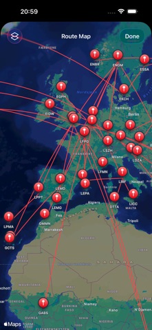
Airport Log & Route Tracking
Keep track of your aviation journey with a powerful Airport Log system.
• Log visited airports and flown routes
• Advanced statistics and route analysis
• Filter by year, aircraft type, airport, and route
• Interactive maps and route visualizations
• Import and export support for backups and data sharing
• Route frequency tracking and airport visit statistics
• Great-circle route mapping and distance calculations
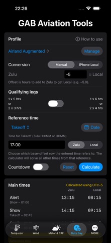
Duty Day Calculator
• Customizable crew rules and limitations
• Multiple time formats: UTC, Local Time, and Countdown
• Saved profiles and persistent configurations
• Duty, FDP, and reporting calculations
Weather & METAR/TAF Decoding
• METAR and TAF decoding
• Visibility, RVR, clouds, weather phenomena, and RMK decoding
• Zulu and airport-local time presentation
• Saved weather groups and parallel group updates
• Cached weather support for offline access
• Automatic TAF source fallback
Holding Entry Trainer (ICAO / FAA)
• Direct, Parallel, and Teardrop/Offset entries
• ICAO and FAA modes
• Automatic sector determination
Temperature & Altitude Corrections
• ICAO Doc 8168 temperature corrections
• Pressure Altitude and Density Altitude calculations
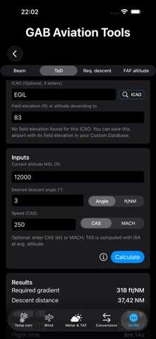
Descent, Approach & Flight Planning Tools
• Descent planning calculators
• Top-of-Descent calculations
• Turn radius and bank angle calculations
• Flight time planning tools
Crosswind & Performance Tools
• Headwind, tailwind, and crosswind calculations
• Aircraft-specific wind limits
Conversions & Aviation Calculators
• Speed, distance, altitude, pressure, temperature, weight, volume, and time conversions
Airport, Callsign & Registration Lookup
• Airport Lookup
• Callsign Lookup
• Aircraft Registration Lookup
• Aviation Abbreviations Lookup
Training & Utility Tools
• Morse Code Trainer
• SELCAL Trainer
• Display flashlight with Home Screen quick actions
• Sunrise, Sunset, Moonrise, and Moonset calculations
• Coordinate selection and mapping tools
• Aviation calendar and operational references
Data & Standards
• Based on ICAO procedures and operational concepts, including ICAO Doc 8168
• Weather data via NOAA Aviation Weather and supporting sources
• Live ADS-B traffic and historical tracks from ADSB.lol under ODbL
• Optional live glider traffic from the Open Glider Network under ODbL
• Airport and timezone data from the mwGG airportsdata dataset under the MIT License
• Offline support for saved tools, profiles, logs, and cached weather data
• No subscriptions or advertising
• No advertising-based user tracking