

GPS Geotag Map Camera - Tagofy
GPS Geotag Map Camera - Tagofy is made and published by Pravin Gondaliya. AppBrain is an independent app data site and isn't affiliated with Pravin Gondaliya. The app name, icon, screenshots and description belong to Pravin Gondaliya and are shown as published on the App Store.
AppBrain's verdict
Well rated- Rating on App Store
- 4.49
- 660 ratings
- Last updated
- September 9, 2026
- Size
- 129.1 MB
Users rate it well: 4.5 stars from 660 ratings.
User feedback
Ratings and reviews on the App StoreComments on GPS Geotag Map Camera - Tagofy for iOS
We don't have enough comments to show example comments. Please check back later.
Store listing
By Pravin Gondaliya, from the App Store


Description by Pravin Gondaliya Written by the developer, not by AppBrain. Click to read.
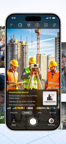
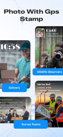
Keep track of your location and the current time along with your captured photos using a Tagofy - Geotag Map Camera. Share your geotagged photos with your family and friends to let them know about your amazing travel experiences.
Whether it's your memorable moments or your adventures at a specific destination, use the Tagofy - Geotag Map Camera feature. Make your photos more meaningful with geotags using the GPS Camera. Share the location of the streets and places featured in your photos with your loved ones, and share your best travel memories and adventures from around the world.
To add GPS location to photos, follow these steps:
1. Install the Tagofy - Geotag Map Camera app from your device's App Store.
2. Open the app & click on the stamp that appears on the screen, Customize the stamp as per your choice.
3. Customize the format & arrangement to suit your needs. Adjust the settings for the GPS location stamp according to your needs.
4. Now, when you take a photo within the app, it will automatically add GPS location stamps to your photos, displaying the exact location on your photos.
Some interesting features of the Tagofy - Geotag Map Camera app include:
1. Custom GPS camera with options for grid, ratio, front & selfie camera, flash, focus, mirror, timer, and capture sound support.
2. Automatic location data setting for added convenience.
3. Classic template that automatically fetches stamp details, simplifying the process of adding info to your photos.
4. Capture high-quality videos with adjustable quality and bitrate, choosing between MOV and MP4 formats.
5. Experiment with time-lapse Video recording, with video stabilisation.
6. Utilize mirror front camera, capture photos with customisable settings.
7. Access a built-in QR scanner.
8. Explore user-friendly timelapse interface, and customize the side panel with shortcut buttons (text, tags, lock screen).
9. Configure email settings for easy sharing, and explore additional functionalities in settings.
In the Advance Template section of the Tagofy - Geotag Map Camera app, you can:
1. Address: Add your chosen automatic location to the photo or input it manually as needed.
2. Date & Time: Add date & timestamp in various formats as an image tag.
3. Logo: Upload your own brand logo to personalize your photos.
4. Note: Write relevant notes or descriptions for your photos.
5. Hashtags: Include hashtags related to your photos using this GPS app for better organization & discoverability.
Tagofy - Geotag Map Camera app on your smartphone offers several benefits, such as:
1. Adding GPS location stamps to your photos.
2. Adding geotag stamps to your photos.
3. Adding photo location stamps.
4. Include Address, date-time & location stamps to your photos.
Tagofy - Geotag Map Camera isn't just a photography tool; it's a powerful companion for explorers, adventurers, and storytellers. Whether you're backpacking across the globe, capturing family gatherings, or documenting your city strolls, our app is designed to make your memories last a lifetime.
Disclaimer:
- This app offers paid features that require an additional purchase for full access. To enjoy all the content and functionality, a subscription is required.
- Street View displays previously captured imagery and is not a live or real-time camera feed. Images may not reflect current conditions.
Privacy Policy: https://tagofy.app/privacy_policy
Terms & Service: https://tagofy.app/terms_of_use
Safety and technology
Found in the app by AppBrain- Price
- Free
- App size
- 129.1 MB
- Content rating
- Everyone
Technologies used by GPS Geotag Map Camera - Tagofy
Releases
Updates seen on the App Store- Version
- 4.6
- Launched
- August 2023
No changelog data
Alternatives
Similar apps and more from Pravin GondaliyaAlternatives to GPS Geotag Map Camera - Tagofy




More from Pravin Gondaliya


Rankings
App Store top chartsApp Store Rankings for GPS Geotag Map Camera - Tagofy
About the app and developer
About GPS Geotag Map Camera - Tagofy
GPS Geotag Map Camera - Tagofy is a photo & video app developed by Pravin Gondaliya.
What is the rating of GPS Geotag Map Camera - Tagofy?
GPS Geotag Map Camera - Tagofy is rated 4.49 out of 5 stars, based on 660 ratings.
Is GPS Geotag Map Camera - Tagofy free?
GPS Geotag Map Camera - Tagofy is free. The app size is 129.08 MB. The latest version available is 4.6. The last update was on September 9, 2026.
What are the requirements for GPS Geotag Map Camera - Tagofy?
The app has a content rating of Everyone. The app has been available on the App Store since August 2023.
Developer information for Pravin Gondaliya
Address:
Frequently asked questions about GPS Geotag Map Camera - Tagofy
Is GPS Geotag Map Camera - Tagofy free?
Yes. GPS Geotag Map Camera - Tagofy is free on the App Store.
Is GPS Geotag Map Camera - Tagofy still available?
Yes. GPS Geotag Map Camera - Tagofy is on the App Store, and the last update we saw was on September 9, 2026.
How large is GPS Geotag Map Camera - Tagofy?
GPS Geotag Map Camera - Tagofy is 129.08 MB.
Is GPS Geotag Map Camera - Tagofy suitable for children?
App Store rates the content of GPS Geotag Map Camera - Tagofy as suitable for everyone.
How do people rate GPS Geotag Map Camera - Tagofy?
GPS Geotag Map Camera - Tagofy scores 4.49 out of 5 stars, from 660 ratings on the App Store.
Who made GPS Geotag Map Camera - Tagofy?
GPS Geotag Map Camera - Tagofy was developed by Pravin Gondaliya. It is listed in the photo & video category on the App Store.
What are the best alternatives to GPS Geotag Map Camera - Tagofy?
People looking at GPS Geotag Map Camera - Tagofy also look at these photo & video apps: Timestamp Camera - GPS Camera, GPS Camera - Location Stamp, GPS Camera Snapshot, GPS camera Lite: Geotag Photo, GPS Camera with Time Stamp App.