

LRTK is made and published by レフィクシア株式会社. AppBrain is an independent app data site and isn't affiliated with レフィクシア株式会社. The app name, icon, screenshots and description belong to レフィクシア株式会社 and are shown as published on the App Store.
AppBrain's verdict
- Last updated
- October 17, 2026
Rankings
App Store top chartsApp Store Rankings for LRTK
Competitors
Similar apps and more from レフィクシア株式会社Alternatives to LRTK


Releases
Updates seen on the App Store- Version
- 2.1.27
- Launched
- August 2022
No changelog data
User feedback
Ratings and reviews on the App StoreComments on LRTK for iOS
We don't have enough comments to show example comments. Please check back later.
Technology
Found in the app by AppBrain- Price
- Free
- App size
- 875.0 MB
- Content rating
- Everyone
Technologies used by LRTK
About the app and developer
About LRTK
LRTK is a productivity app developed by レフィクシア株式会社.
User Ratings
The app has no ratings yet.
App Information
LRTK is freely available from the App Store. The app size is 874.99 MB. The latest version available is 2.1.27. The last update was on October 17, 2026.
Technical Requirements
The app has a content rating of Everyone. The app has been available on the App Store since August 2022.
Developer information for レフィクシア株式会社
Address:
Frequently asked questions about LRTK
Is LRTK free?
Yes. LRTK is free on the App Store.
Is LRTK still available?
Yes. LRTK is on the App Store, and the last update we saw was on October 17, 2026.
How large is LRTK?
LRTK is 874.99 MB.
Is LRTK suitable for children?
App Store rates the content of LRTK as suitable for everyone.
Who made LRTK?
LRTK was developed by レフィクシア株式会社. It is listed in the productivity category on the App Store.
What are the best alternatives to LRTK?
People looking at LRTK also look at these productivity apps: mapry建築, Scanat, BAIAS, XactiViewer.
Store listing
By レフィクシア株式会社, from the App Store


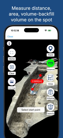
Description by レフィクシア株式会社 Written by the developer, not by AppBrain. Click to read.
This is the dedicated app for the "LRTK" centimeter-level GNSS device (*1).
By connecting to the LRTK receiver and configuring Network RTK (NtripClient), you can achieve centimeter-level positioning accuracy.
Through integration with the LRTK Cloud (*2), captured location data can be instantly synced and viewed via a web browser.
Key Features & Use Cases:
• Easy access to high-accuracy surveying.
• Instantly share field survey data with office PCs.
• Manage location data alongside site photos.
• Easily acquire point cloud data.
Note on Altitude Calculation:
To obtain JGD2011 (Japan Geodetic Datum 2011) altitude, this app utilizes the calculation API provided by the Geospatial Information Authority of Japan (*3).
(*1) https://www.lefixea.com/lrtk
(*2) https://lconstruction.lefixea.jp/
(*3) https://vldb.gsi.go.jp/sokuchi/surveycalc/api_help.html