




AppBrain's verdict
Established- Rating on App Store
- 4.97
- 94 ratings
- Last updated
- August 26, 2026
- Size
- 109.5 MB
It doesn't have enough ratings yet to judge what users think.
User feedback
Ratings and reviews on the App StoreComments on Mt. Fuji - GPS Trail Map for iOS
We don't have enough comments to show example comments. Please check back later.
Store listing
By YAMARECO INC., from the App StoreDescription by YAMARECO INC. Written by the developer, not by AppBrain. Click to read.
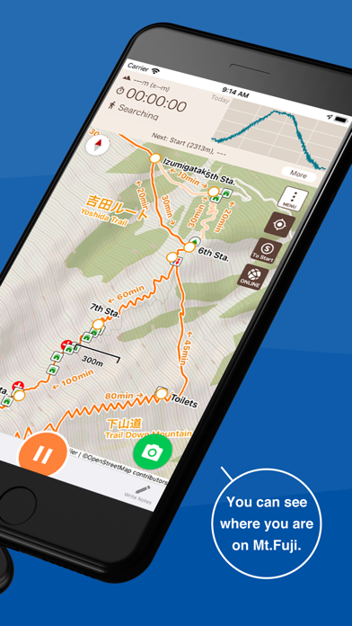
It utilizes data such as maps, routes, and place names that can be used for climbing Mt. Fuji, and allows you to check your current location with GPS even in the mountains where the Internet connection is not available.
Features
(1) Offline trail map
Mt. Fuji trail maps can be used offline.
Even in the mountains where there is no internet connection, you can use the signal from GPS satellites to locate your current location and display the map.
(2) Easy preparation
You can start hiking by simply selecting your trail route from the four routes commonly used for climbing Mt. Fuji.
(3) Mountain hut/lodge information
You can also make reservations by phone or through the website for huts located along your planned route.
(4) Leave history of your hike
When you start climbing a mountain, you can store a GPS log of your hike using GPS.
Even if you are on airplane mode or out of range, if the sky is open, you can store a GPS log using satellite signals.
After you finished your hike, you can get your own Climbing Certificate of Mt. Fuji.
(5) Voice notification of wrong way
When you deviate from the planned route, you will be notified by voice.
You can also use the speech function that periodically notifies you of the current time and elevation after you start climbing.
(6) Easy to keep a record of your hike
You can easily create a record of your hike using the GPS logs and photos you took while climbing!
You can also export the GPS log or post it directly to Yamareco (in Japanese only).
(7) Latest Mt. Fuji conditions
By signing in YamaReco, you can check other people's Mt. Fuji records and check the current mountain conditions.
Knowing the current mountain conditions can help you prepare appropriately.
(8) Useful Information
The app includes information such as downhill bus timetable, mountain insurance, equipment, access, and related links useful for climbing Mt. Fuji.
Notes
When keeping a GPS log, the GPS function is used continuously in the background, which may drain the battery faster than apps that do not use GPS.
Continued use of GPS running in the background can dramatically decrease battery life.
Please be sure to bring a paper map, compass, spare batteries, and power cable with you when climbing mountains.
To use some of the functions of this application, you will need to register as a user with YamaReco.
How to use the application
https://sites.google.com/view/fuji-ios-en/
Safety and technology
Found in the app by AppBrain- Price
- Free
- App size
- 109.5 MB
- Content rating
- Everyone
Technologies used by Mt. Fuji - GPS Trail Map
Releases
Updates seen on the App Store- Version
- 26.35.0
- Launched
- June 2021
No changelog data
Alternatives
Similar apps and more from YAMARECO INC.





Rankings
App Store top chartsApp Store Rankings for Mt. Fuji - GPS Trail Map
About the app and developer
About Mt. Fuji - GPS Trail Map
Mt. Fuji - GPS Trail Map is a navigation app developed by YAMARECO INC.
User Ratings
Mt. Fuji - GPS Trail Map is rated 4.97 out of 5 stars. The rating is based on 94 ratings.
App Information
Mt. Fuji - GPS Trail Map is freely available from the App Store. The app size is 109.52 MB. The latest version available is 26.35.0. The last update was on August 26, 2026.
Technical Requirements
The app has a content rating of Everyone. The app has been available on the App Store since June 2021.
Mt. Fuji - GPS Trail Map is made and published by YAMARECO INC. AppBrain is an independent app data site and isn't affiliated with YAMARECO INC. The app name, icon, screenshots and description belong to YAMARECO INC. and are shown as published on the App Store.
Developer information for YAMARECO INC.
Address:
Frequently asked questions about Mt. Fuji - GPS Trail Map
Is Mt. Fuji - GPS Trail Map free?
Yes. Mt. Fuji - GPS Trail Map is free on the App Store.
Is Mt. Fuji - GPS Trail Map still available?
Yes. Mt. Fuji - GPS Trail Map is on the App Store, and the last update we saw was on August 26, 2026.
How large is Mt. Fuji - GPS Trail Map?
Mt. Fuji - GPS Trail Map is 109.52 MB.
Is Mt. Fuji - GPS Trail Map suitable for children?
App Store rates the content of Mt. Fuji - GPS Trail Map as suitable for everyone.
How do people rate Mt. Fuji - GPS Trail Map?
Mt. Fuji - GPS Trail Map scores 4.97 out of 5 stars, from 94 ratings on the App Store.
Who made Mt. Fuji - GPS Trail Map?
Mt. Fuji - GPS Trail Map was developed by YAMARECO INC. It is listed in the navigation category on the App Store.
What are the best alternatives to Mt. Fuji - GPS Trail Map?
People looking at Mt. Fuji - GPS Trail Map also look at these navigation apps: LUUP - RIDE YOUR CITY, ON THE TRIP A Traveler's Guide, LEGOLAND® Japan Resort, Imperial Palaces Guide, Japan Transit Planner - Travel.