

Rhumb: Sea Charts & Navigation
Rhumb: Sea Charts & Navigation is made and published by Yes Please Boats Ltd. AppBrain is an independent app data site and isn't affiliated with Yes Please Boats Ltd. The app name, icon, screenshots and description belong to Yes Please Boats Ltd and are shown as published on the App Store.
AppBrain's verdict
- Last updated
- October 9, 2026
- Size
- 11.2 MB
User feedback
Ratings and reviews on the App StoreComments on Rhumb: Sea Charts & Navigation for iOS
We don't have enough comments to show example comments. Please check back later.
Store listing
By Yes Please Boats Ltd, from the App Store


Description by Yes Please Boats Ltd Written by the developer, not by AppBrain. Click to read.
Rhumb is built by a Yachtmaster Offshore skipper who uses it on his own passages. It is made for people learning to navigate — RYA Day Skipper level and below — for skippers who forget the details between seasons, and for anyone in a dinghy, RIB, kayak, or on a paddleboard who wants a clear view of the seamarks around them. Crew on someone else's boat get their own view of position, course, and speed from the free tier.
THE CHART
• The whole world's chart included — buoys, beacons, lights, and harbour marks from OpenSeaMap on a clean base map
• North-up, always — the chart never rotates; your boat and your course do
• Day, twilight, and night appearances that switch automatically with the sun at your position
• Your position, course over ground (COG), and speed over ground (SOG), live on the chart
• Rhumb needs a data connection for the chart today; offline charts are in development
NAVIGATE
• Dividers: rhumb-line distance and bearing between any two points, in nautical miles and °T
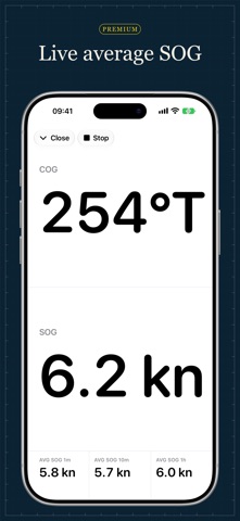
• Full-screen instruments: COG and SOG, readable at arm's length at the helm
• Markers: name and categorise anchorages, hazards, and marinas — stored in your own private iCloud, where only you can read them
RHUMB PREMIUM
• Auto-routing: tap waypoints and get a route that avoids land, with distance for every leg
• Average SOG over the last minute, ten minutes, and hour — live on the instruments, kept complete in the background. Watch the tide help or hurt on passage.
• £19.99 a year or £3.99 a month, with a one-week free trial. The chart and navigation essentials stay free, and you can cancel in your Apple Account settings at any time.
The subscription renews automatically unless cancelled at least 24 hours before the end of the current period. Payment is charged to your Apple Account.
IMPORTANT
Rhumb is an aid for recreational planning. It does not replace official charts, official publications, or safe navigation practice. Routes avoid land. They do not check depth, so always verify depths against your chart.
Terms of Use: https://rhumbapp.com/terms
Privacy Policy: https://rhumbapp.com/privacy
Safety and technology
Found in the app by AppBrain- Price
- Free
- App size
- 11.2 MB
- Content rating
- Everyone
Technologies used by Rhumb: Sea Charts & Navigation
Releases
Updates seen on the App Store- Version
- 1.2
- Launched
- August 2026
No changelog data
Alternatives
Similar apps and more from Yes Please Boats LtdMore from Yes Please Boats Ltd


Also available on Google Play

Rankings
App Store top chartsApp Store Rankings for Rhumb: Sea Charts & Navigation
About the app and developer
About Rhumb: Sea Charts & Navigation
Rhumb: Sea Charts & Navigation is a navigation app developed by Yes Please Boats Ltd.
User Ratings
The app has no ratings yet.
App Information
Rhumb: Sea Charts & Navigation is freely available from the App Store. The app size is 11.19 MB. The latest version available is 1.2. The last update was on October 9, 2026.
Technical Requirements
The app has a content rating of Everyone. The app has been available on the App Store since August 2026.
Developer information for Yes Please Boats Ltd
Address:
Frequently asked questions about Rhumb: Sea Charts & Navigation
Is Rhumb: Sea Charts & Navigation free?
Yes. Rhumb: Sea Charts & Navigation is free on the App Store.
Is Rhumb: Sea Charts & Navigation still available?
Yes. Rhumb: Sea Charts & Navigation is on the App Store, and the last update we saw was on October 9, 2026.
How large is Rhumb: Sea Charts & Navigation?
Rhumb: Sea Charts & Navigation is 11.19 MB.
Is Rhumb: Sea Charts & Navigation suitable for children?
App Store rates the content of Rhumb: Sea Charts & Navigation as suitable for everyone.
Who made Rhumb: Sea Charts & Navigation?
Rhumb: Sea Charts & Navigation was developed by Yes Please Boats Ltd. It is listed in the navigation category on the App Store.