rRuf is an overall app developed by Rival Solutions.
Download Statistics
User Ratings
The app has no ratings yet.
App Information
rRuf is FREE to download. The APK download size is 4.59 MB. The latest version available is 4.0.2. The last update was on September 16, 2021.
Technical Requirements
The app has a content rating of Everyone. The app has been available on Google Play February 2015.
Description
rRuf ('Road Roughness') is a mobile application that allows managers, engineers, technicians, or the travelling public to measure a userís response to the roughness of a road and reported in a scale known as a Riding Comfort Index (RCI). Ride comfort, from roughness, is a function of the road surface condition and underlying structural adequacy, and is a key quality indicator for roadway engineers and managers. Road roughness directly impacts vehicle and transportation user costs. The rRuf app is used as part of a larger cloud based infrastructure management process, called toy.
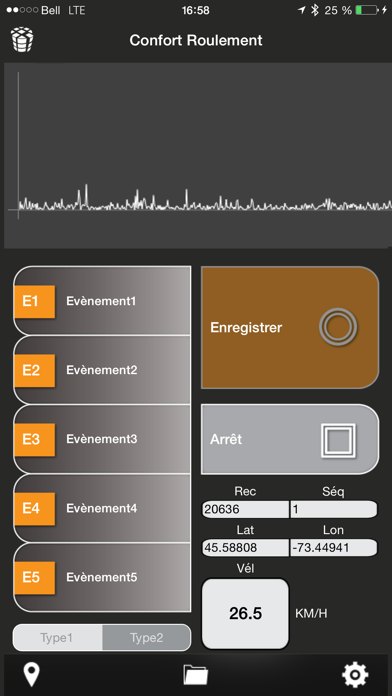
rRuf automatically records and transfers raw data through toy cloud services to produce a response based road roughness condition rating. This is accomplished through the aggregation and processing of location (GNSS), motion (acceleration) and base centerline mapping data within the toy workflow.
In all, rRuf and the toy utility provide infrastructure and roadway managers a turn-key solution for evaluating roadway infrastructure condition. To leverage the full functionality of rRuf, users need to have an active toy subscription.
rRuf produces raw data and when processed by the toy servers, the following results can be optioned nearly instantaneously from a web dashboard: -Roughness and Ride Comfort Index (eg scale of 1-10) color-coded; -Results that are reported by an input map (i.e. block to block, milepost,etc); -Results reported in smaller intervals (eg 100 meters); -Overall production maps indicating what roads have been driven with a score or not; -Statistical information (avg, min, max, stdev) for each segment for data such as speed and acceleration; -Breadcrumb trail of the vehicles location; -Event locations logged in the app.
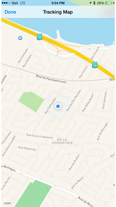
The rRuf app itself provides the following functionality: - Recording of geolocated acceleration raw data to csv files; - Manual roadway geolocated information entries (events and types); - Auto pause during vehicle stops; - Manual and automated emailing of recorded data. - Location maps; - Sampling frequency configuration; - Project specific configuration fields; - Auto compression of data files.
Each subscription will automatically renew 3 days before the expiration date for
the same time period. Subscriptions can be cancelled at any time before the renewal.