US EFB - Aviation Charts is a weather app developed by Flygo-Aviation Ltd.
What is the rating of US EFB - Aviation Charts?
US EFB - Aviation Charts is rated 4.34 out of 5 stars, based on 44 ratings.
Is US EFB - Aviation Charts free?
US EFB - Aviation Charts is free. The app size is 12.72 MB. The latest version available is 4.1. The last update was on October 23, 2026.
What are the requirements for US EFB - Aviation Charts?
The app has a content rating of Everyone. The app has been available on the App Store since March 2017.
Description by Flygo-Aviation Ltd(from the App Store)
US EFB – Aviation Charts puts the FAA terminal procedures and VFR charts of the United States in your flight bag: more than 24,000 charts for over 3,000 airports, current every 28-day cycle.
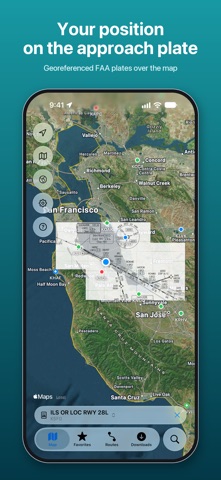
YOUR POSITION ON THE PLATE • About 9 in 10 approach charts are georeferenced: the app shows your aircraft on the plan view, with track and accuracy. • Lay an approach plate over the map, adjust its opacity, and switch to another runway's approach with one tap.
PROCEDURES ON THE MAP • Departures, arrivals and approaches drawn to scale from the FAA CIFP: transitions, the final approach and a dashed missed approach. • Runway numbers and thresholds appear when you zoom in on an airport.
VFR CHARTS • FAA sectional and terminal area charts over the map, seamless from one chart to the next, with your position and the airports' weather on top. • Download the charts you fly with and use them offline; each 56-day edition is installed when you choose.
WEATHER AT A GLANCE • Airports on the map are colored by flight category (VFR, MVFR, IFR, LIFR) from the latest METAR. • Decoded METAR and TAF in your units, sunrise and sunset in UTC.
AIRPORTS • Search by FAA, ICAO or IATA identifier, name or city; nearby airports with distance and bearing. • Charts sorted by category and runway: airport diagram, approaches, STARs, departures, minimums, hot spots. • FAA airport data: runways with length, width and surface, elevation, magnetic variation, tower, owner and manager.
READY BEFORE YOU FLY • Download an airport or a whole route, alternates included, and open the charts without a connection. • The next cycle is downloaded about three weeks ahead with your offline charts, and takes over at 0901Z on the effective date, even without a connection. • Routes with alternates, favorites and recent airports.
Designed for iPhone and iPad, with a full-screen map and Liquid Glass controls.
FREE AND PRO Free: the map with weather, airport information and airport diagrams. Aviation Charts Pro: every terminal procedure, VFR charts, offline charts, routes, and plates and procedures on the map. Annual or monthly subscription, each with a one-week free trial. Payment is charged to your Apple Account at confirmation of purchase. The subscription renews automatically unless it is turned off at least 24 hours before the end of the current period. Manage or cancel it in your Apple Account settings.
The charts are the official FAA d-TPP and VFR raster chart publications. Always confirm with official sources and NOTAMs before flight; position display and procedure lines are for situational awareness, not primary navigation.
Privacy policy: https://www.flygo-aviation.com/privacy-policy-flygo/ Terms of use: https://www.flygo-aviation.com/terms-of-use-flygo/
Each subscription will automatically renew 3 days before the expiration date for
the same time period. Subscriptions can be cancelled at any time before the renewal.