Waymarked Trail Explorer is a travel app developed by Marcel Petersen.
User Ratings
The app has no ratings yet.
App Information
Waymarked Trail Explorer is FREE to download. The download size is 5.92 MB. The latest version available is 1.0.70. The last update was on August 18, 2026.
Technical Requirements
The app has a content rating of Everyone. The app has been available on the App Store since June 2026.
Description
Explore official walking routes, long-distance trails, hiking paths and famous walking trails near you with one tap on the map.
Waymarked Trail Explorer instantly shows hiking and walking routes around your location, from local forest trails and regional paths to famous long-distance routes such as the Pieterpad, GR5 and Camino de Santiago.
Find a walking route near you Planning a walk in the Netherlands, hiking through the Ardennes, exploring the Alps or following the Camino de Santiago? Waymarked Trail Explorer helps you find marked walking routes wherever you are.
Browse nearby trails directly on the map and quickly find inspiration for your next hike, day walk or multi-day adventure.
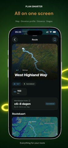
Route details at a glance Tap any walking route to view the complete trail on the map.
See useful information including: - Total route distance - Elevation profile and elevation changes -Route stages and sections - Full trail geometry - Route classification - Nearby trail locations
Want to see what the surroundings look like before you start? Explore locations along the trail at street level using Apple Look Around.
Explore hiking routes in 3D Flyover mode lets you preview an entire route using a smooth 3D map animation.
Follow the trail from start to finish, see how the route moves through the landscape and explore unfamiliar hiking areas before heading outside.
Simple hiking route discovery No account. No subscription. No advertising.
Open the app, tap the map and start exploring.
Features Find walking and hiking routes with one tap Explore nearby hiking trails on an interactive map Search local, regional, national and international routes View complete walking routes and long-distance trails Check distance, elevation and route stages Preview routes using animated 3D Flyover Explore trail locations with Apple Look Around Switch between standard and satellite maps Find famous routes including long-distance and pilgrimage trails Worldwide trail coverage Route information based on OpenStreetMap open data Made for walkers and hikers
Waymarked Trail Explorer is designed for hikers, walkers, pilgrims, families, travellers and anyone looking for new places to walk.
Explore trails across the Netherlands, Belgium, France, Germany, Spain, the rest of Europe and destinations around the world.
From a short local walk to an international long-distance trail, your next route starts on the map.
Download Waymarked Trail Explorer and find your next hiking trail today.
Each subscription will automatically renew 3 days before the expiration date for
the same time period. Subscriptions can be cancelled at any time before the renewal.