Android Apps
>
Maps & Navigation
> Paid
Category
Maps & Navigation
Sort by
Trending
Recent downloads
All-time downloads
Top rated
Popular in
Filter by
Off
Free
Paid
New
Updated
Price Reduced
No ads
Page 10 of the popular Paid Maps & Navigation Apps for Android in Italy
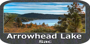
Arrowhead Lake Sac IOWA Charts
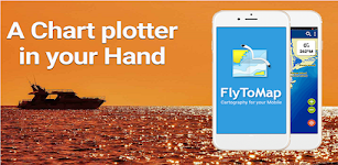
FLYTOMAP

Flytomap is a valid and interesting alternative,
Featured on the Deck
Featured on Geomedia
Worldwide Marine and Outdoor Maps available when connected, thanks to viewer.flytomap.com
Worldwide Satellit…


$2.99
0.0
1+ downloads
|
Maps & Navigation
0.0
$2.99
FLYTOMAP
1+ downloads
TRANSPORTATION
1+ downloads
TRANSPORTATION
Arrowhead Lake Sac IOWA Charts
Flytomap is a valid and interesting alternative,
Featured on the Deck
Featured on Geomedia
Worldwide Marine and Outdoor…
Lake Tahoe California GPS Maps
FLYTOMAP INC

Flytomap is a valid and interesting alternative,
Worldwide Marine and Outdoor Maps available when connected, thanks to viewer.flytomap.com
Worldwide Satellite images overlay on charts
Worldwide Ter…

$3.99
0.0
10+ downloads
|
Maps & Navigation
0.0
$3.99
FLYTOMAP INC
10+ downloads
TRANSPORTATION
10+ downloads
TRANSPORTATION
Lake Tahoe California GPS Maps
Flytomap is a valid and interesting alternative,
Worldwide Marine and Outdoor Maps available when connected, thanks to…
DronES
Reporting Estándar S.L.

En la app dronES hemos combinado dos aplicaciones en una. Busca en el mapa la zona donde vas a volar o usa tus coordenadas actuales. Consulta las restricciones al vuelo usando los mismos servicios qu…


$5.49
0.0
100+ downloads
|
Maps & Navigation
0.0
$5.49
Reporting Estándar S.L.
100+ downloads
TRANSPORTATION
100+ downloads
TRANSPORTATION
DronES
En la app dronES hemos combinado dos aplicaciones en una. Busca en el mapa la zona donde vas a volar o usa tus coordena…
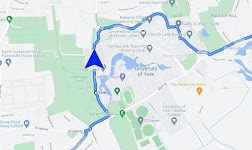
Satnav Cycle Routes – York
Ian Lochhead

3 Satnav Cycle Routes around York.
1. Around York - 19.5 miles
2. York to Stamford Bridge - 28.3 miles
3. York to Tadcaster - 21.3 miles
Satnav Cycle Routes around York using cycle paths and roads. …


$0.99
0.0
0+ downloads
|
Maps & Navigation
0.0
$0.99
Ian Lochhead
0+ downloads
TRANSPORTATION
0+ downloads
TRANSPORTATION
Satnav Cycle Routes – York
3 Satnav Cycle Routes around York.
1. Around York - 19.5 miles
2. York to Stamford Bridge - 28.3 miles
3. York to Tadca…
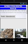
Satnav Cycle Routes – Perth(2)
Ian Lochhead

Perth - Glenalmond. 35 miles
Perth - Crieff. 38 miles
Perth - Milnathort. 38 miles
Satnav Cycle Routes around Perth using cycle paths and roads. Every route has turn-by-turn navigation with voice in…


$0.99
0.0
0+ downloads
|
Maps & Navigation
0.0
$0.99
Ian Lochhead
0+ downloads
TRANSPORTATION
0+ downloads
TRANSPORTATION
Satnav Cycle Routes – Perth(2)
Perth - Glenalmond. 35 miles
Perth - Crieff. 38 miles
Perth - Milnathort. 38 miles
Satnav Cycle Routes around Perth us…
Satnav CycleRoutes–Dunfermline
Ian Lochhead

Dunfermline - Kincardine. 28.6 miles
Dunfermline - Limekilns. 14.4 miles
Satnav Cycle Routes around Dunfermline using cycle paths and roads. Every route has turn-by-turn navigation with voice instru…


$0.99
0.0
0+ downloads
|
Maps & Navigation
0.0
$0.99
Ian Lochhead
0+ downloads
TRANSPORTATION
0+ downloads
TRANSPORTATION
Satnav CycleRoutes–Dunfermline
Dunfermline - Kincardine. 28.6 miles
Dunfermline - Limekilns. 14.4 miles
Satnav Cycle Routes around Dunfermline using …
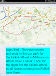
Satnav Cycle Routes – Falkirk
Ian Lochhead

Around the Falkirk Wheel. 12.5 miles
Falkirk - Avonbridge. 24 miles
Falkirk - Fannyside Loch. 20 miles
Falkirk Wheel & Helix Park. 12 miles
Satnav Cycle Routes around Falkirk using cycle paths a…


$0.99
0.0
1+ downloads
|
Maps & Navigation
0.0
$0.99
Ian Lochhead
1+ downloads
TRANSPORTATION
1+ downloads
TRANSPORTATION
Satnav Cycle Routes – Falkirk
Around the Falkirk Wheel. 12.5 miles
Falkirk - Avonbridge. 24 miles
Falkirk - Fannyside Loch. 20 miles
Falkirk Wheel &a…
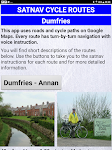
Satnav Cycle Routes - Dumfries
Ian Lochhead

Dumfries - Annan. 43 miles
Dumfries - Lochmabon. 40 miles
Dumfries - New Abbey. 27 miles
3 Satnav Cycle Routes around Dumfries using cycle paths and roads on Google Maps. Every route has turn-by-tur…


$0.99
0.0
0+ downloads
|
Maps & Navigation
0.0
$0.99
Ian Lochhead
0+ downloads
TRANSPORTATION
0+ downloads
TRANSPORTATION
Satnav Cycle Routes - Dumfries
Dumfries - Annan. 43 miles
Dumfries - Lochmabon. 40 miles
Dumfries - New Abbey. 27 miles
3 Satnav Cycle Routes around …
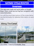
Satnav Cycle Routes –Inverness
Ian Lochhead

Satnav Cycle Routes around Inverness using cycle paths and quiet roads. Every route has turn-by-turn navigation with voice instruction. Enjoy the benefits of cycling a whole route by following Sat Na…


$0.99
0.0
0+ downloads
|
Maps & Navigation
0.0
$0.99
Ian Lochhead
0+ downloads
TRANSPORTATION
0+ downloads
TRANSPORTATION
Satnav Cycle Routes –Inverness
Satnav Cycle Routes around Inverness using cycle paths and quiet roads. Every route has turn-by-turn navigation with vo…
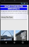
Satnav Cycle Routes-Newcastle1
Ian Lochhead

1. Along the Tyne - 15 miles
2. Newcastle to Gateshead - 23.5 miles
3. Newcastle to Sunderland - 39 miles
Satnav Cycle Routes around Newcastle using cycle paths and roads. Every route has turn-by-tu…


$0.99
0.0
0+ downloads
|
Maps & Navigation
0.0
$0.99
Ian Lochhead
0+ downloads
TRANSPORTATION
0+ downloads
TRANSPORTATION
Satnav Cycle Routes-Newcastle1
1. Along the Tyne - 15 miles
2. Newcastle to Gateshead - 23.5 miles
3. Newcastle to Sunderland - 39 miles
Satnav Cycle…
Satnav Cycle Routes -Dundee(2)
Ian Lochhead

Dundee - Piperdam. 23 miles
Dundee - Carnoustie. 31 miles
Satnav Cycle Routes around Dundee using cycle paths and roads. Every route has turn-by-turn navigation with voice instruction. Enjoy the ben…


$0.99
0.0
0+ downloads
|
Maps & Navigation
0.0
$0.99
Ian Lochhead
0+ downloads
TRANSPORTATION
0+ downloads
TRANSPORTATION
Satnav Cycle Routes -Dundee(2)
Dundee - Piperdam. 23 miles
Dundee - Carnoustie. 31 miles
Satnav Cycle Routes around Dundee using cycle paths and road…
Mille Lacs Gps Map Navigator
FLYTOMAP INC

Flytomap is a valid and interesting alternative,
Featured on the Deck
Featured on Geomedia
Worldwide Marine and Outdoor Maps available when connected, thanks to viewer.flytomap.com
Worldwide Satelli…


$3.99
0.0
50+ downloads
|
Maps & Navigation
0.0
$3.99
FLYTOMAP INC
50+ downloads
TRANSPORTATION
50+ downloads
TRANSPORTATION
Mille Lacs Gps Map Navigator
Flytomap is a valid and interesting alternative,
Featured on the Deck
Featured on Geomedia
Worldwide Marine and Outdoo…
Channel Islands Offline Map
XDivide Geospatial

Designed with simplicity in mind, this app offers an intuitive user interface that enables you to quickly and easily find information about surroundings, without any prior technical knowledge or expe…


$0.99
0.0
0+ downloads
|
Maps & Navigation
0.0
$0.99
XDivide Geospatial
0+ downloads
TRANSPORTATION
0+ downloads
TRANSPORTATION
Channel Islands Offline Map
Designed with simplicity in mind, this app offers an intuitive user interface that enables you to quickly and easily fi…
Kärnten Lakes - Austria Charts
MAPITECH LTD

MapiTech launches on the market the best official up-to-date combined with S57 nautical charts (digital): marinas, wrecks, fishing spots, boat ramps, POI.
Lakes in this App : Aichwaldsee,AfritzerSe…


$4.99
0.0
5+ downloads
|
Maps & Navigation
0.0
$4.99
MAPITECH LTD
5+ downloads
TRANSPORTATION
5+ downloads
TRANSPORTATION
Kärnten Lakes - Austria Charts
MapiTech launches on the market the best official up-to-date combined with S57 nautical charts (digital): marinas, wre…
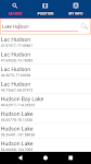
Lake Hudson GPS Map Navigator
FLYTOMAP INC

Flytomap is a valid and interesting alternative,
Featured on the Deck
Featured on Geomedia
Worldwide Marine and Outdoor Maps available when connected, thanks to viewer.flytomap.com
Worldwide Satelli…


$3.99
0.0
0+ downloads
|
Maps & Navigation
0.0
$3.99
FLYTOMAP INC
0+ downloads
TRANSPORTATION
0+ downloads
TRANSPORTATION
Lake Hudson GPS Map Navigator
Flytomap is a valid and interesting alternative,
Featured on the Deck
Featured on Geomedia
Worldwide Marine and Outdoo…
Smith Mountain Lake GPS Charts
FLYTOMAP INC

Flytomap is a valid and interesting alternative,
Featured on the Deck
Featured on Geomedia
Worldwide Marine and Outdoor Maps available when connected, thanks to viewer.flytomap.com
Worldwide Satellit…


$3.99
0.0
50+ downloads
|
Maps & Navigation
0.0
$3.99
FLYTOMAP INC
50+ downloads
TRANSPORTATION
50+ downloads
TRANSPORTATION
Smith Mountain Lake GPS Charts
Flytomap is a valid and interesting alternative,
Featured on the Deck
Featured on Geomedia
Worldwide Marine and Outdoor…
GPS Attitude
Bergin-IT

GPS Attitude displays and saves to file GPS position, direction and rotation of an Android phone or tablet. The data can be sent to another IP address on the same WiFi network.
An XYZ adjacent posit…


$4.49
0.0
500+ downloads
|
Maps & Navigation
0.0
$4.49
Bergin-IT
500+ downloads
TRANSPORTATION
500+ downloads
TRANSPORTATION
GPS Attitude
GPS Attitude displays and saves to file GPS position, direction and rotation of an Android phone or tablet. The data ca…
BackCountry Navigator GPS PRO
CritterMap Software LLC

Download topo maps for an offline outdoor navigator! Use your phone or tablet as an offroad topo mapping handheld GPS with the bestselling outdoor navigation app for Android! Explore beyond cell cove…


$14.99
3.6
100,000+ downloads
|
Maps & Navigation
3.6
$14.99
CritterMap Software LLC
100,000+ downloads
TRANSPORTATION
100,000+ downloads
TRANSPORTATION
BackCountry Navigator GPS PRO
Download topo maps for an offline outdoor navigator! Use your phone or tablet as an offroad topo mapping handheld GPS w…
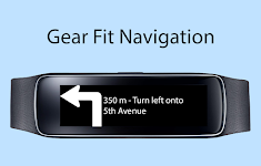
Gear Fit Navigation
SmartWatch Studios

This application displays Google Navigation instructions on your Samsung Gear Fit 1 smartwatch. (Not compatible with Gear Fit2!)
Note:
- Supports horizontal and vertical layout
- Additional to the …


$1.99
3.3
10,000+ downloads
|
Maps & Navigation
3.3
$1.99
SmartWatch Studios
10,000+ downloads
TRANSPORTATION
10,000+ downloads
TRANSPORTATION
Gear Fit Navigation
This application displays Google Navigation instructions on your Samsung Gear Fit 1 smartwatch. (Not compatible with Ge…
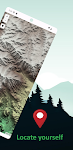
Guadalupe Mountain Offline Map
XDivide Geospatial

Designed with simplicity in mind, this app offers an intuitive user interface that enables you to quickly and easily find information about surroundings, without any prior technical knowledge or expe…


$0.99
0.0
1+ downloads
|
Maps & Navigation
0.0
$0.99
XDivide Geospatial
1+ downloads
TRANSPORTATION
1+ downloads
TRANSPORTATION
Guadalupe Mountain Offline Map
Designed with simplicity in mind, this app offers an intuitive user interface that enables you to quickly and easily fi…

More apps
Android Statistics
About AppBrain
© 2010-2024 - AppBrain