

Marine Navigation
Marine Navigation is made and published by Marco Palaferri. AppBrain is an independent app data site and isn't affiliated with Marco Palaferri. The app name, icon, screenshots and description belong to Marco Palaferri and are shown as published on Google Play.
AppBrain's verdict
Established- Rating on Google Play
- 3.43
- 385 ratings
- Installs
- 14 thousand
- Last updated
- October 13, 2026
- Ads
- No ads
- Size
- 73.6 MB
Marine Navigation has 14 thousand installs. Users are divided: 3.4 stars from 385 ratings.
User feedback
Ratings and reviews on Google PlayComments on Marine Navigation for Android
Google Play Rating history and histogram
Store listing
By Marco Palaferri, from Google Play“S57 & Custom Maps. We Respect Your Privacy. One-Time Purchase. Trusted since '09”




Description by Marco Palaferri Written by the developer, not by AppBrain. Click to read.
Tired of apps renting your maps every year? Worried about your secret fishing spots being tracked or sold? It’s time to take back control.
Marine Navigation is the GPS chartplotter you buy once and own for life. No hidden fees, no forced subscriptions. Since 2009, sailors, fishermen, and sea lovers have trusted us for reliable, offline navigation that respects their privacy.
CHOOSE YOUR WAY TO NAVIGATE
Try Free: Download Marine Navigation Lite to explore the basics.
Full Version (One-Time Purchase): Get the complete offline chartplotter that’s yours forever.
Go PRO (Optional Subscription): Unlock professional-grade tools and navigate without limits.
Your choice: own it once, or subscribe for more — total freedom.
GO PRO — THE ULTIMATE NAVIGATION
For the serious navigator, we built something extraordinary. The PRO version is more than just features; it's a commitment to professional-grade technology, passionately built by a single developer.
PROPRIETARY S57 ENGINE (NEW): This is our masterpiece. Our custom S57 renderer brings official Electronic Navigational Charts (ENC) to your device with a speed and detail once reserved for systems costing thousands. This isn't a licensed feature; it's core technology built for performance.
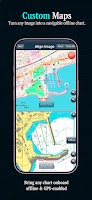
UNLIMITED CUSTOM MAPS: Our most revolutionary feature, supercharged. Scan a paper chart, import a satellite image of a wreck, or even use a treasure map. Our powerful georeferencing tool lets you turn any image into a fully navigable, offline chart in minutes. Your knowledge, mapped.
GLOBAL OFFLINE TIDES: Accurate tidal data for any point on the map, calculated on your device. No internet needed, powered by the high-precision FES2022b global model.
ADVANCED TOOLS: Overlay multiple maps, adjust transparency, and gain a level of control that competitors simply cannot match.
FISH FORECAST (NEW): Fish Forecast helps you plan fishing trips with an Activity Score, built from Solunar, plus real fishing weather and ocean conditions.
YOUR DATA IS SACRED
We respect your privacy. We don’t track you. We don’t analyze your locations. We never sell your data. Everything you save stays safely on your device. Your fishing spots remain yours — always.
FULL VERSION — EVERYTHING YOU NEED
RELIABLE OFFLINE MAPS: Download your charts and navigate with confidence far from shore. Our entire download system has been rebuilt from the ground up based on user feedback for total clarity and control.
COMPLETE GPS NAVIGATION: Routes, tracks, unlimited waypoints, anchor alarm, compass (true/magnetic), speed, and direction.
WIDE CHART SELECTION: Access NOAA Raster & ENC, ESRI Satellite Imagery, OpenSeaMap, Bathymetric Maps, and more.
USEFUL TOOLS: Basic weather, moon phases, GPX import/export.
WHY CHOOSE MARINE NAVIGATION?
Freedom of Choice: Buy once for life, or subscribe to PRO — you decide.
Privacy First: Your data stays on your device, period.
Unmatched Control: From official S57 charts to your own custom maps.
Trusted by Navigators Worldwide: Reliable and independent since 2009.
IMPORTANT NOTICE
Good seamanship requires the use of official charts. Marine Navigation is for use with other charts and cannot replace official charts. Use at your own risk.
SUBSCRIPTION INFORMATION
The subscription renews automatically unless turned off at least 24 hours before the end of the current period.
You can manage or disable auto-renew in your Google Play account after purchase.
Learn more on our official website:
www.fishpoints.net
Terms of Use:
http://www.fishpoints.net/eula/
Privacy Policy:
http://www.fishpoints.net/privacy-policy/
Try Marine Navigation and take the helm of your journey. The sea is yours
Recent changes:
Added GPS-based heading fallback support.
New Fish Forecast: Smart GPS, My Spots & Map Explore—scout bite potential worldwide using solunar + meteo/ocean data. Cleaner Waypoints UI with smart actions
Safety and technology
Found in the app by AppBrain- Ads
- No ads
- Price
- $19.99
- Libraries
- 27
- App size
- 73.6 MB
- Needs Android
- 9.0+
- Content rating
- Everyone
Technologies used by Marine Navigation
Releases
Updates seen on Google Play- Version
- 16.8.20
- Launched
- October 2012
Alternatives
Similar apps and more from Marco PalaferriAlternatives to Marine Navigation


More from Marco Palaferri


Installs
Tracked by AppBrain- Last 30 days
- 13
- Play install range
- 10+ thousand
- Launched
- October 2012
Installs over time
Marine Navigation has been installed 14 thousand times. Over the past 30 days, it has been installed 13 times.
Rankings
Google Play top chartsGoogle Play Rankings for Marine Navigation
About the app and developer
About Marine Navigation
Marine Navigation is a maps & navigation app developed by Marco Palaferri.
Install Statistics
Marine Navigation has been installed 14 thousand times. In the last 30 days, the app was installed 13 times.
User Ratings
Marine Navigation is rated 3.43 out of 5 stars. The rating is based on 390 ratings.
App Information
Marine Navigation costs $19.99. The app size is 73.64 MB. The latest version available is 16.8.20. The last update was on October 13, 2026.
Technical Requirements
Marine Navigation requires Android 9.0+ or higher. The app has a content rating of Everyone. The app has been available on Google Play since October 2012.
App Performance Report
Get a detailed PDF report for Marine Navigation with download trends, rating history, and key performance statistics — useful for competitive research or tracking your own app. Learn more
Get PDF Report — $29Developer information for Marco Palaferri
Frequently asked questions about Marine Navigation
Is Marine Navigation free?
No. Marine Navigation costs $19.99 on Google Play.
Is Marine Navigation still available?
Yes. Marine Navigation is on Google Play, and the last update we saw was on October 13, 2026.
Does Marine Navigation contain ads?
No. Google Play does not list Marine Navigation as containing ads.
What Android version does Marine Navigation require?
Marine Navigation runs on Android 9.0 and higher.
How large is Marine Navigation?
Marine Navigation is 73.64 MB.
Is Marine Navigation suitable for children?
Google Play rates the content of Marine Navigation as suitable for everyone.
How many times has Marine Navigation been installed?
Google Play lists 10,000+ installs for Marine Navigation.
How do people rate Marine Navigation?
Marine Navigation scores 3.43 out of 5 stars, from 385 ratings on Google Play.
Who made Marine Navigation?
Marine Navigation was developed by Marco Palaferri. It is listed in the maps & navigation category on Google Play.
What are the best alternatives to Marine Navigation?
People looking at Marine Navigation also look at these maps & navigation apps: TZ iBoat - Marine Navigation, Wavve Boating: Marine Boat GPS, Argo - Boat Navigation GPS, Simrad: Companion for Boaters, Garmin ActiveCaptain®.