

WinGPS™ Marine is made and published by Stentec. AppBrain is an independent app data site and isn't affiliated with Stentec. The app name, icon, screenshots and description belong to Stentec and are shown as published on Google Play.
AppBrain's verdict
EstablishedPoorly rated- Total installs
- 270 thousand
- Rating on Google Play
- 2.82
- 928 ratings
- Last updated
- July 2, 2026
WinGPS™ Marine has 270 thousand installs. Users are critical: 2.8 stars from 928 ratings.
Installs
Tracked by AppBrain- Last 30 days
- 260
- Play install range
- 100+ thousand
- Launched
- March 2014
Installs over time
WinGPS™ Marine has been installed 270 thousand times. Over the past 30 days, it has been installed 260 times.
Rankings
Google Play top chartsGoogle Play Rankings for WinGPS™ Marine
Competitors
Similar apps and more from StentecAlternatives to WinGPS™ Marine


More from Stentec


Releases
Updates seen on Google Play- Version
- 5.01
- Launched
- March 2014
User feedback
Ratings and reviews on Google PlayGoogle Play Rating history and histogram
Comments on WinGPS™ Marine for Android
Technology
Found in the app by AppBrain- Ads
- No ads
- Price
- Free
- Libraries
- 8
- App size
- 7.27 MB
- Needs Android
- 5.0+
- Content rating
- Everyone
Technologies used by WinGPS™ Marine
About the app and developer
About WinGPS™ Marine
WinGPS™ Marine is a maps & navigation app developed by Stentec.
Install Statistics
WinGPS™ Marine has been installed 270 thousand times. In the last 30 days, the app was installed 260 times.
User Ratings
WinGPS™ Marine is rated 2.82 out of 5 stars. The rating is based on 930 ratings.
App Information
WinGPS™ Marine is freely available from Google Play. The app size is 7.27 MB. The latest version available is 5.01. The last update was on July 2, 2026.
Technical Requirements
WinGPS™ Marine requires Android 5.0+ or higher. The app has a content rating of Everyone. The app has been available on Google Play since March 2014.
App Performance Report
Get a detailed PDF report for WinGPS™ Marine with download trends, rating history, and key performance statistics — useful for competitive research or tracking your own app. Learn more
Get PDF Report — $29Developer information for Stentec
Frequently asked questions about WinGPS™ Marine
Is WinGPS™ Marine free?
Yes. WinGPS™ Marine is free on Google Play.
Is WinGPS™ Marine still available?
Yes. WinGPS™ Marine is on Google Play, and the last update we saw was on July 2, 2026.
Does WinGPS™ Marine contain ads?
No. Google Play does not list WinGPS™ Marine as containing ads.
What Android version does WinGPS™ Marine require?
WinGPS™ Marine runs on Android 5.0 and higher.
How large is WinGPS™ Marine?
WinGPS™ Marine is 7.27 MB.
Is WinGPS™ Marine suitable for children?
Google Play rates the content of WinGPS™ Marine as suitable for everyone.
How many times has WinGPS™ Marine been installed?
Google Play lists 100,000+ installs for WinGPS™ Marine.
How do people rate WinGPS™ Marine?
WinGPS™ Marine scores 2.82 out of 5 stars, from 928 ratings on Google Play.
Who made WinGPS™ Marine?
WinGPS™ Marine was developed by Stentec. It is listed in the maps & navigation category on Google Play.
What are the best alternatives to WinGPS™ Marine?
People looking at WinGPS™ Marine also look at these maps & navigation apps: Savvy Navvy Boating Navigation, NavShip - Waterway Routing, KnowWake, Waterway Guide, Polaris GPS Hike, Bike, Marine.
Store listing
By Stentec, from Google Play“Your tablet, smartphone or watch as a personal navigation system on board.”


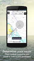


Description by Stentec Written by the developer, not by AppBrain. Click to read.
Developed by Stentec for navigation on sailing and motor yachts, sloops and canoes at sea, tidal and inland waters. Ideal when renting or chartering a boat.
• Support for the waterways for the inland charts Western Europe and Donau with bridge-, locks and waterway information. With this you can plot and adjust your routes quickly, indicating any obstacles. The names of the waterways and distances will be shown during your trip.
• Smart labeling prevents overlapping text labels (with waterways also) for an optimal chart image. Bridge and lock data will always be readable on Course Up rotating charts.
HIGHLIGHTS
• Navigating on up-to-date charts of Stentec, Imray, NOAA and Delius Klasing.
• SD-card support for chart storage.
• Manage tracks, charts, routes and waypoints.
• NOAA World GRIB-files: wind, air pressure, rainfall and temperature.
• Connect AIS and GPS via wirelesss WIFI or Bluetooth connection.
• Prevent collisions with the speed vectors of the AIS ships.
• Man-overboard button helps to retrieve lost crewmembers.
• Chart moves along underneath centered GPS position. NorthUp, CourseUp (Marine) or HeadUp (Plus).
• Wear OS companion: live navigation data on your wrist, with a watch tile for speed, heading and course at a glance.
• Harmoniemodel KNMI with detailed weather predictions (Plus, Netherlands only)
• NOAA wave prediction at open sea (Plus, Worldwide)
When WinGPS Marine is installed for the first time, this will be WinGPS Marine Lite with limited functions. Ideal as a chart viewer with GPS support.
IN-APP PURCHASE
After purchasing WinGPS Marine, you will unlock the full capabilities of your personal navigation system. You are now able to plot routes, download GRIB files, save previous tracks and connect AIS and GPS. Use the handy time table to view the predicted wind, rain, air pressure and AIS targets.
With the WinGPS Marine Plus upgrade, you will be able to connect additional board instruments via wireless connection to you board PC, multiplexer or AIS transponder. You can display current and tidal information in your data plotter or view it on the chart. Also, the advanced KNMI’s Harmonie weather model is supported as well as the NOAA waves worldwide.
KUSTFIJN Getijmodel Rijkswaterstaat with two day wind depended predictions of currents, tides and water levels on the Waddenzee, Ijsselmeer, Markermeer, Randmeren and Zeeland. Red depth lines limit the safe waterways depending on depth, tides and deviations because of the wind.
CHART COVERAGE & INSTALLING THE CHARTS
When you start WinGPS Marine you will automatically see the (online) topographic default chart of ESRI. You can also turn on the NOAA charts of the US and download the free world chart via the Chart Manager
For safe navigation, you can purchase digital charts at www.stentec.com. It’s also possible to purchase the charts in the app or via Google Play™. Your charts can be installed on 3 different devices. For example, on your Android tablet, phone and Windows laptop or computer.
Log in with your Stentec Account in the Marine app and download or update your purchased DKW2 charts in the Chart Manager.
For example, the popular DKW1800 series with weekly BaZ updates and the NL Chart with biweekly updates. Our online shop offers up-to-date sea charts and all inland charts of Western Europa including the Donau.
More information:
www.wingpsmarine.com
Privacy policy:
www.stentec.com/en/en/privacy-statement
USERS INPUT
For improvement of the app we are very much interested in your experience and suggestions. Please send an e-mail to helpdesk@stentec.com.
Recent changes:
- Various fixes.