Everything you expect from a full electronic flight bag, the whole workflow from planning on the ground to the approach.
MAPS AND CHARTS
• VFR sectionals, terminal area charts and flyway charts
• IFR enroute low and high, Caribbean/Mexico low and high, and oceanic
• In house VFR-style chart for the entire world
• Satellite imagery basemap
• Georeference approach plates, airport diagrams, takeoff minimums, Chart Supplement
AIRPORTS
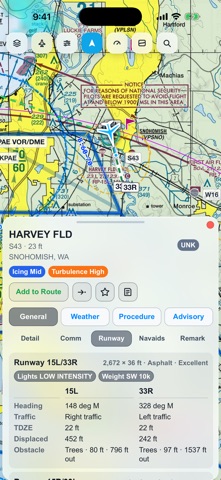
• Runway lengths, widths, surfaces, TDZE, thresholds, pattern direction
• Frequencies, ATIS and D-ATIS, flow control, fuel and services
• Your aircraft's takeoff and landing numbers for each runway
• NOTAM Highlights: the few that matter, above the sixty that do not
• NOTAMs grouped into runway, taxiway, procedure, airspace and other
• Favorites, direct-to, and add-to-route from any airport
WEATHER
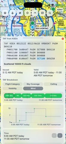
• METARs and TAFs — tap any token in the raw text to decode it in place
• PIREPs, winds and temperatures aloft anywhere on earth, MOS/LAMP guidance
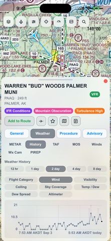
• Up to 8 days of station history, charted nine different ways
• Animated radar with a time slider, and surface analysis
• Infrared satellite that follows where you are looking — GOES and Himawari
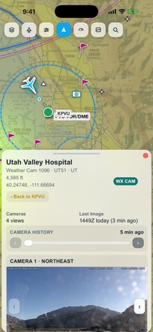
• Airport weather cameras with 24hrs of history
• Color airport symbols by flight category, wind, ceiling, visibility or ATIS
• Loaded weather stays available offline
ADVISORIES AND AIRSPACE
• SIGMETs including international, AIRMETs and TFRs
• Controlled and special-use airspace worldwide, floors and ceilings labelled
• Live FAA feeds: runway visual range, wind shear, airspace activation, traffic flow
• Military training routes, obstacles, MVA/MIA sectors
• Navaids, fixes, VFR reporting points, and low/high airways
PROCEDURES
• Approaches, departures and arrivals plotted on the map
• Filter approaches by ILS, LOC or GPS, grouped by runway
• Load an approach with its transition or vectors and fly it in the route
FLIGHT PLANNING
• Type a route with airway expansion, or pull preferred and coded ones
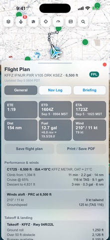
• Trip planner: aircraft profile, altitude, power setting, fuel on board
• Nav log with leg headings, distances, times and fuel
• Winds-aloft-corrected times, with climb, cruise and descent performance
• Fuel plan with taxi, enroute, reserve and block
• Full briefing, and a printable flight package or PDF
IN FLIGHT
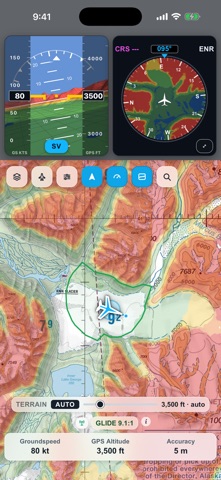
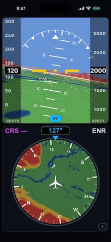
• Synthetic-vision PFD with terrain ahead, an HSI, and full-screen instruments
• Terrain shaded against your selected altitude
• Glide ring from your current height
• ADS-B traffic from portable GDL 90 receivers over Wi-Fi
• Sim Connect: MSFS and X-Plane over your home network
• Own-ship that degrades honestly when the GPS fix does
• Live groundspeed, GPS altitude, track, vertical speed and Zulu time
• Two-finger measure for distance and bearing
DOWNLOAD AND CURRENCY
• Download FAA charts, plates and data by region and by product
• 28-day data and 56-day chart cycles, with a cycle picker
• Fully usable with no connection once downloaded
IMPORTANT
This app is an advisory aid for situational awareness only. It is not certified for navigation and must not be used as a primary means of navigation, or for terrain or traffic avoidance. Traffic from a portable receiver will not include all aircraft. Always carry current official charts and comply with your operating rules. Data comes from the FAA, NOAA/NWS, openAIP, NASA and OpenStreetMap; verify currency before every flight.
Show more
Show less