

Land Area Measure
Land Area Measure is made and published by MEP TASARIM MUHENDISLIK VE MUSAVIRLIK LIMITED SIRKETI. AppBrain is an independent app data site and isn't affiliated with MEP TASARIM MUHENDISLIK VE MUSAVIRLIK LIMITED SIRKETI. The app name, icon, screenshots and description belong to MEP TASARIM MUHENDISLIK VE MUSAVIRLIK LIMITED SIRKETI and are shown as published on the App Store.
AppBrain's verdict
- Last updated
- August 22, 2026
Rankings
App Store top chartsApp Store Rankings for Land Area Measure
Competitors
Similar apps and more from MEP TASARIM MUHENDISLIK VE MUSAVIRLIK LIMITED SIRKETIAlternatives to Land Area Measure




Releases
Updates seen on the App Store- Version
- 0.1.1
- Launched
- August 2026
No changelog data
User feedback
Ratings and reviews on the App StoreComments on Land Area Measure for iOS
We don't have enough comments to show example comments. Please check back later.
Technology
Found in the app by AppBrain- Price
- Free
- App size
- 6.66 MB
- Content rating
- Everyone
Technologies used by Land Area Measure
About the app and developer
About Land Area Measure
Land Area Measure is an utilities app developed by MEP TASARIM MUHENDISLIK VE MUSAVIRLIK LIMITED SIRKETI.
What is the rating of Land Area Measure?
Land Area Measure has no ratings yet.
Is Land Area Measure free?
Land Area Measure is free. The app size is 6.66 MB. The latest version available is 0.1.1. The last update was on August 22, 2026.
What are the requirements for Land Area Measure?
The app has a content rating of Everyone. The app has been available on the App Store since August 2026.
Developer information for MEP TASARIM MUHENDISLIK VE MUSAVIRLIK LIMITED SIRKETI
Store listing
By MEP TASARIM MUHENDISLIK VE MUSAVIRLIK LIMITED SIRKETI, from the App Store



Description by MEP TASARIM MUHENDISLIK VE MUSAVIRLIK LIMITED SIRKETI Written by the developer, not by AppBrain. Click to read.
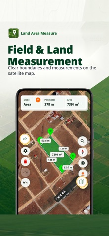
Add points on the map to calculate area, perimeter, and distance. You can also start GPS Area or GPS Distance sessions when location permission is granted. Save measurements locally on your device and share supported projects as KML or GeoJSON.
Core features:
• Manual point placement, movement, undo, and deletion
• Area, perimeter, and distance calculations
• Square meter, hectare, and local land-unit display support
• User-started GPS Area and GPS Distance sessions
• Saved projects for reopening or deleting local measurements
• KML and GeoJSON export through the iOS share sheet
• Manual measurement remains available without location permission
Privacy and trust:
• Measurement projects are stored locally on your device.
• Location is used for current-location recentering and explicit user-started GPS measurement sessions.
• An active GPS session may continue while the screen is locked or the app is not visible, with the visible iOS location indicator, until you choose Stop.
• The app does not request Always location authorization, start hidden tracking, or silently restart tracking after termination.
• Banner ads do not interrupt measurement workflows. A one-time in-app purchase is available to remove ads.
Important:
Results are for information only. This app does not provide official survey, cadastral, title, parcel-boundary, engineering, or legal measurement documents. Verify official work with the relevant authority or a licensed professional.