

PlanSnap: LiDAR Floor Plan
PlanSnap: LiDAR Floor Plan is made and published by Josh Mustafa. AppBrain is an independent app data site and isn't affiliated with Josh Mustafa. The app name, icon, screenshots and description belong to Josh Mustafa and are shown as published on the App Store.
AppBrain's verdict
- Last updated
- September 29, 2026
- Size
- 14.0 MB
User feedback
Ratings and reviews on the App StoreComments on PlanSnap: LiDAR Floor Plan for iOS
We don't have enough comments to show example comments. Please check back later.
Store listing
By Josh Mustafa, from the App Store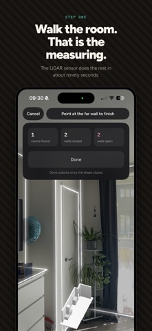


Description by Josh Mustafa Written by the developer, not by AppBrain. Click to read.
No account. No cloud. Your scans never leave the phone.
YOUR SCANS STAY ON YOUR PHONE
PlanSnap has no backend. Capture, room detection, measurement and export all happen on device, so it works in a basement with no signal and the only copy of your property is the one you keep.
Two outside services are involved, and neither one ever receives a scan, an image, a measurement or an address: RevenueCat handles subscriptions and sees purchase events, and an anonymous crash and diagnostics reporter tells us when something breaks.
ONE SCAN, THE WHOLE PACK
Each property exports as one folder:
• A floor plan PNG for every floor
• Two hero images sized for listing sites
• A PDF floor plan ready to print
• A dimensions and square footage text file
• A room schedule CSV
• A metadata file recording when and how it was measured
Real files you own. They go into a listing, a report, an email, an archive.
SQUARE FOOTAGE, ROOM BY ROOM
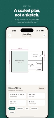
PlanSnap traces the walls, splits the scan into rooms, names them, and measures each room along its own walls rather than square to the compass, so a house sitting at an angle still reports honest numbers. Square footage per room, dimensions per room, and a total for the floor. Feet or meters, switch whenever you like.
Scan floor by floor and PlanSnap assembles them into one property with one schedule and one total.
BUILT FOR
• Listing agents and real estate photographers who need the plan and the square footage the same day
• Landlords and property managers documenting a unit at move in and move out
• Contractors, remodelers and designers who need dimensions before quoting
• Homeowners checking the house against the tax record
A DATED, LOCATED RECORD
Give PlanSnap a location fix and exports carry the date, GPS coordinates and a hash that reveals tampering, so a condition record shows when and where it was captured and can be checked later against that stamp. Free tier stamps are marked as such. Without a location fix, no stamp is produced.
FREE AND PAID
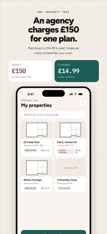
Free: one property, every floor of it, watermarked exports. Nothing is cut back. Every measurement and every file is there. Delete the property to scan another.
PlanSnap Pro removes the watermark and lifts the one property limit. It is available as a weekly subscription with a 3 day free trial, a monthly subscription, or an annual subscription. Prices are shown in your local currency on the purchase screen before you confirm.
Payment is charged to your Apple Account at confirmation of purchase. Subscriptions renew automatically unless automatic renewal is switched off at least 24 hours before the current period ends. Manage or cancel in your Apple Account settings.
WHAT YOU NEED
An iPhone Pro or Pro Max with a LiDAR sensor, iPhone 12 Pro or later, running iOS 17 or later. LiDAR is what makes the measurements true to scale. Without it the app cannot scan.
ACCURACY
Measurements come from the LiDAR sensor and are typically within 1 to 2% in good lighting. PlanSnap is for marketing, planning and record keeping. It is not a licensed appraisal, a land survey or a structural engineering report, and it is not certified to any measurement standard. Verify square footage independently before publishing it in a listing.
https://www.apple.com/legal/internet-services/itunes/dev/stdeula/
Safety and technology
Found in the app by AppBrain- Price
- Free
- App size
- 14.0 MB
- Content rating
- Medium
Technologies used by PlanSnap: LiDAR Floor Plan
Releases
Updates seen on the App Store- Version
- 1.2.0
- Launched
- April 2026
No changelog data
Alternatives
Similar apps and more from Josh MustafaAlternatives to PlanSnap: LiDAR Floor Plan


More from Josh Mustafa


Rankings
App Store top chartsApp Store Rankings for PlanSnap: LiDAR Floor Plan
About the app and developer
About PlanSnap: LiDAR Floor Plan
PlanSnap: LiDAR Floor Plan is a business app developed by Josh Mustafa.
User Ratings
The app has no ratings yet.
App Information
PlanSnap: LiDAR Floor Plan is freely available from the App Store. The app size is 14.02 MB. The latest version available is 1.2.0. The last update was on September 29, 2026.
Technical Requirements
The app has a content rating of Medium Maturity. The app has been available on the App Store since April 2026.
Developer information for Josh Mustafa
Address: